Saint-Germain-de-Grantham geodata
Saint-Germain-de-Grantham (Quebec) is a populated place; located in Canada in America/Toronto (GMT-4) time zone. With population of 3,485 people, there are 573 cities with bigger population in this country. Compared to other cities in Canada, 67.3% of cities are located further ↑North; 74.2% of cities are located further ←West and 63% of cities have higher elevation than Saint-Germain-de-Grantham. Note1
Administrative division(s):
- Level 1: Quebec
- Level 2: Centre-du-Québec
- Level 3: Saint-Germain-de-Grantham
Current local time in Saint-Germain-de-Grantham:
05:19 AM, FridayDifference from your time zone: hours


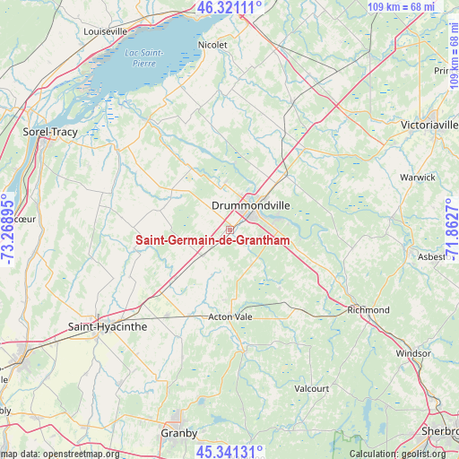
Saint-Germain-de-Grantham GPS coordinates[2]
45° 50' 0.132" North, 72° 33' 56.952" West
| Map corner | latitude | longitude |
|---|---|---|
| Upper-left | 46.32111°, | -73.26895° |
| Center: | 45.83337°, | -72.56582° |
| Lower-right: | 45.34131°, | -71.8627° |
| Map W x H: | 108.9×108.9 km | = 67.7×67.7mi |
| max Lat: | 73.03752° ⇑67.3% North |
| Saint-Germain-de-Grantham: | 45.83337° |
| min Lat: | ⇓32.7% South 42.05009° |
| min Long | Saint-Germain-d | max Long |
| -139.43328° | -72.56582° | -52.70931° |
| W 74.2%⇐ | ⇒25.8% E |
Elevation
Elevation of Saint-Germain-de-Grantham is 86 m = 282 ft, and this is 168.4 m = 552 ft below average elevation for this country.
| Max E: |
1518 m = 4980 ft | 63% |
| Avg. | 254.4 m = 835 ft | |
| Saint-Germain-de-Grantham | 86 m = 282 ft | |
Min E: |
-2 m = -7 ft | 37% |
See also: Canada elevation on elevation.city.
Geographical zone
Saint-Germain-de-Grantham is located in North temperate zone (between Tropic of Cancer and the Arctic Circle). Distance of this North polar circle is 2305 km =1432.3 mi to North.| Distance of | km | miles | from Saint-Germain-de-Grantham |
|---|---|---|---|
| North Pole | 4910.9 | 3051.5 | to North |
| Arctic Circle | 2305 | 1432.3 | to North |
| Tropic Cancer | 2490.3 | 1547.4 | to South |
| Equator | 5096.2 | 3166.6 | to South |


Nearby cities:
15 places around Saint-Germain-de-Grantham: (largest is in red/bold)
• Acton Vale
20.4 km =12.7 mi,  180°
180°
• Danville
43 km =26.7 mi,  97°
97°
• Drummondville
8.5 km =5.3 mi,  49°
49°
• Kingsey Falls
38.8 km =24.1 mi,  87°
87°
• Nicolet
42.8 km =26.6 mi,  354°
354°
• Pierreville
32.5 km =20.2 mi,  324°
324°
• Richmond
37.3 km =23.2 mi,  119°
119°
• Saint-Barnabé-Sud
30 km =18.6 mi,  247°
247°
• Saint-Cyrille-de-Wendover
15.2 km =9.4 mi,  42°
42°
• Saint-Hyacinthe
37.8 km =23.5 mi,  233°
233°
• Saint-Liboire
25.5 km =15.8 mi,  217°
217°
• Saint-Léonard-d'Aston
33.4 km =20.8 mi,  27°
27°
• Saint-Pie
45.4 km =28.2 mi, 215°
• Saint-Pie-V
23.5 km =14.6 mi, 323°
• Valcourt
41.8 km =26 mi,  152°
152°
Sources, notices
• [Note1] Compared only with cities in Canada existing in our database
• [Src1] Map data: © OpenStreetMap contributors (CC-BY-SA)
• [Src2] Other city data from geonames.org with taken over terms of usage.
• [Src3] Geographical zone / Annual Mean Temperature by Robert A. Rohde @ Wikipedia
