Nicolet geodata
Nicolet (Quebec) is a populated place; located in Canada in America/Toronto (GMT-4) time zone. With population of 5,669 people, there are 444 cities with bigger population in this country. Compared to other cities in Canada, 59.1% of cities are located further ↑North; 74% of cities are located further ←West and 85.9% of cities have higher elevation than Nicolet. Note1


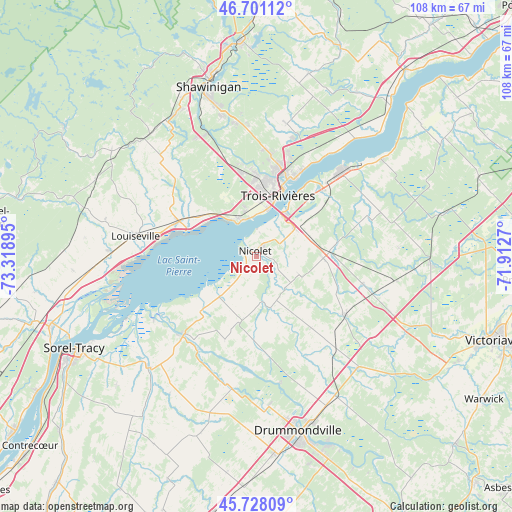
Nicolet GPS coordinates[2]
46° 13' 0.336" North, 72° 36' 56.952" West
| Map corner | latitude | longitude |
|---|---|---|
| Upper-left | 46.70112°, | -73.31895° |
| Center: | 46.21676°, | -72.61582° |
| Lower-right: | 45.72809°, | -71.9127° |
| Map W x H: | 108.2×108.2 km | = 67.2×67.2mi |
| max Lat: | 73.03752° ⇑59.1% North |
| Nicolet: | 46.21676° |
| min Lat: | ⇓40.9% South 42.05009° |
| min Long | Nicolet | max Long |
| -139.43328° | -72.61582° | -52.70931° |
| W 74%⇐ | ⇒26% E |
Elevation
Elevation of Nicolet is 20 m = 66 ft, and this is 234.4 m = 769 ft below average elevation for this country.
| Max E: |
1518 m = 4980 ft | 85.9% |
| Avg. | 254.4 m = 835 ft | |
| Nicolet | 20 m = 66 ft | |
Min E: |
-2 m = -7 ft | 14.1% |
See also: Canada elevation on elevation.city.
Geographical zone
Nicolet is located in North temperate zone (between Tropic of Cancer and the Arctic Circle). Distance of this North polar circle is 2262.4 km =1405.8 mi to North.| Distance of | km | miles | from Nicolet |
|---|---|---|---|
| North Pole | 4868.2 | 3025 | to North |
| Arctic Circle | 2262.4 | 1405.8 | to North |
| Tropic Cancer | 2532.9 | 1573.9 | to South |
| Equator | 5138.8 | 3193.1 | to South |


Nearby cities:
15 places around Nicolet: (largest is in red/bold)
• Bécancour
19.7 km =12.2 mi,  45°
45°
• Daveluyville
37.2 km =23.1 mi,  92°
92°
• Drummondville
38.5 km =23.9 mi,  164°
164°
• Louiseville
25.4 km =15.8 mi,  279°
279°
• Maskinongé
31.1 km =19.3 mi,  272°
272°
• Pierreville
22.2 km =13.8 mi,  222°
222°
• Saint-Cyrille-de-Wendover
34.5 km =21.4 mi, 155°
• Saint-Germain-de-Grantham
42.8 km =26.6 mi,  174°
174°
• Saint-Léonard-d'Aston
23.2 km =14.4 mi,  123°
123°
• Saint-Pie-V
25.8 km =16 mi,  203°
203°
• Sainte-Catherine
11.9 km =7.4 mi,  18°
18°
• Shawinigan
40.2 km =25 mi,  345°
345°
• Sorel-Tracy
43 km =26.7 mi,  243°
243°
• Trois-Rivières
15.2 km =9.4 mi, 20°
• Yamachiche
17.6 km =10.9 mi,  288°
288°
Sources, notices
• [Note1] Compared only with cities in Canada existing in our database
• [Src1] Map data: © OpenStreetMap contributors (CC-BY-SA)
• [Src2] Other city data from geonames.org with taken over terms of usage.
• [Src3] Geographical zone / Annual Mean Temperature by Robert A. Rohde @ Wikipedia
