Pierreville geodata
Pierreville (Quebec) is a populated place; located in Canada in America/Toronto (GMT-4) time zone. With population of 1,119 people, there are 992 cities with bigger population in this country. Compared to other cities in Canada, 61.7% of cities are located further ↑North; 73.1% of cities are located further ←West and 84.1% of cities have higher elevation than Pierreville. Note1


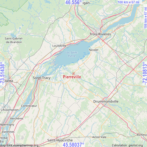
Pierreville GPS coordinates[2]
46° 4' 13.224" North, 72° 48' 40.5" West
| Map corner | latitude | longitude |
|---|---|---|
| Upper-left | 46.556°, | -73.51438° |
| Center: | 46.07034°, | -72.81125° |
| Lower-right: | 45.58037°, | -72.10813° |
| Map W x H: | 108.5×108.5 km | = 67.4×67.4mi |
| max Lat: | 73.03752° ⇑61.7% North |
| Pierreville: | 46.07034° |
| min Lat: | ⇓38.3% South 42.05009° |
| min Long | Pierreville | max Long |
| -139.43328° | -72.81125° | -52.70931° |
| W 73.1%⇐ | ⇒26.9% E |
Elevation
Elevation of Pierreville is 24 m = 79 ft, and this is 230.4 m = 756 ft below average elevation for this country.
| Max E: |
1518 m = 4980 ft | 84.1% |
| Avg. | 254.4 m = 835 ft | |
| Pierreville | 24 m = 79 ft | |
Min E: |
-2 m = -7 ft | 15.9% |
See also: Canada elevation on elevation.city.
Geographical zone
Pierreville is located in North temperate zone (between Tropic of Cancer and the Arctic Circle). Distance of this North polar circle is 2278.6 km =1415.9 mi to North.| Distance of | km | miles | from Pierreville |
|---|---|---|---|
| North Pole | 4884.5 | 3035.1 | to North |
| Arctic Circle | 2278.6 | 1415.9 | to North |
| Tropic Cancer | 2516.6 | 1563.7 | to South |
| Equator | 5122.5 | 3183 | to South |


Nearby cities:
15 places around Pierreville: (largest is in red/bold)
• Berthierville
28.7 km =17.8 mi,  272°
272°
• Drummondville
32.8 km =20.4 mi,  129°
129°
• Lanoraie
33.3 km =20.7 mi,  249°
249°
• Louiseville
22.9 km =14.2 mi,  334°
334°
• Maskinongé
23.8 km =14.8 mi,  317°
317°
• Nicolet
22.2 km =13.8 mi,  42°
42°
• Saint-Cyrille-de-Wendover
33 km =20.5 mi,  117°
117°
• Saint-Germain-de-Grantham
32.5 km =20.2 mi,  144°
144°
• Saint-Joseph
34 km =21.1 mi, 248°
• Saint-Léonard-d'Aston
34.5 km =21.4 mi,  84°
84°
• Saint-Pie-V
8.9 km =5.5 mi,  146°
146°
• Sainte-Catherine
33.4 km =20.8 mi,  34°
34°
• Sorel-Tracy
23.5 km =14.6 mi,  262°
262°
• Trois-Rivières
36.7 km =22.8 mi, 33°
• Yamachiche
21.9 km =13.6 mi,  355°
355°
Sources, notices
• [Note1] Compared only with cities in Canada existing in our database
• [Src1] Map data: © OpenStreetMap contributors (CC-BY-SA)
• [Src2] Other city data from geonames.org with taken over terms of usage.
• [Src3] Geographical zone / Annual Mean Temperature by Robert A. Rohde @ Wikipedia
