Sainte-Anne-des-Plaines geodata
Sainte-Anne-des-Plaines (Quebec) is a populated place; located in Canada in America/Toronto (GMT-4) time zone. With population of 10,680 people, there are 296 cities with bigger population in this country. Compared to other cities in Canada, 68.3% of cities are located further ↑North; 64.6% of cities are located further ←West and 67.2% of cities have higher elevation than Sainte-Anne-des-Plaines. Note1
Current local time in Sainte-Anne-des-Plaines:
03:47 AM, MondayDifference from your time zone: hours


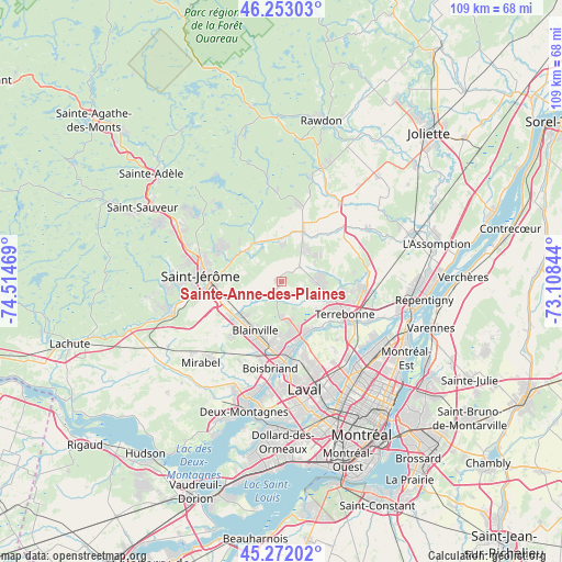
Sainte-Anne-des-Plaines GPS coordinates[2]
45° 45' 52.848" North, 73° 48' 41.616" West
| Map corner | latitude | longitude |
|---|---|---|
| Upper-left | 46.25303°, | -74.51469° |
| Center: | 45.76468°, | -73.81156° |
| Lower-right: | 45.27202°, | -73.10844° |
| Map W x H: | 109.1×109.1 km | = 67.8×67.8mi |
| max Lat: | 73.03752° ⇑68.3% North |
| Sainte-Anne-des-Plaines: | 45.76468° |
| min Lat: | ⇓31.7% South 42.05009° |
| min Long | Sainte-Anne-des | max Long |
| -139.43328° | -73.81156° | -52.70931° |
| W 64.6%⇐ | ⇒35.4% E |
Elevation
Elevation of Sainte-Anne-des-Plaines is 67 m = 220 ft, and this is 187.4 m = 615 ft below average elevation for this country.
| Max E: |
1518 m = 4980 ft | 67.2% |
| Avg. | 254.4 m = 835 ft | |
| Sainte-Anne-des-Plaines | 67 m = 220 ft | |
Min E: |
-2 m = -7 ft | 32.8% |
See also: Canada elevation on elevation.city.
Geographical zone
Sainte-Anne-des-Plaines is located in North temperate zone (between Tropic of Cancer and the Arctic Circle). Distance of this North polar circle is 2312.6 km =1437 mi to North.| Distance of | km | miles | from Sainte-Anne-des-Plaines |
|---|---|---|---|
| North Pole | 4918.5 | 3056.2 | to North |
| Arctic Circle | 2312.6 | 1437 | to North |
| Tropic Cancer | 2482.6 | 1542.6 | to South |
| Equator | 5088.6 | 3161.9 | to South |


Nearby cities:
15 places around Sainte-Anne-des-Plaines: (largest is in red/bold)
• Blainville
12.2 km =7.6 mi,  206°
206°
• Bois-des-Filion
11.9 km =7.4 mi,  156°
156°
• Boisbriand
16.5 km =10.3 mi,  185°
185°
• Lac-Alouette
12.8 km =8 mi,  296°
296°
• Lac-Connelly
19.4 km =12.1 mi,  319°
319°
• Lac-Lapierre
15.2 km =9.4 mi,  11°
11°
• Lorraine
9.3 km =5.8 mi,  165°
165°
• Mascouche
16.5 km =10.3 mi,  95°
95°
• Rosemère
14.6 km =9.1 mi,  176°
176°
• Saint-Elzéar
19.1 km =11.9 mi, 159°
• Saint-Jérôme
15 km =9.3 mi,  276°
276°
• Saint-Lin-Laurentides
10.1 km =6.3 mi,  20°
20°
• Sainte-Sophie
8.9 km =5.5 mi,  310°
310°
• Sainte-Thérèse
14 km =8.7 mi, 185°
• Terrebonne
14.6 km =9.1 mi,  119°
119°
Sources, notices
• [Note1] Compared only with cities in Canada existing in our database
• [Src1] Map data: © OpenStreetMap contributors (CC-BY-SA)
• [Src2] Other city data from geonames.org with taken over terms of usage.
• [Src3] Geographical zone / Annual Mean Temperature by Robert A. Rohde @ Wikipedia
