Lorraine geodata
Lorraine (Quebec) is a populated place; located in Canada in America/Toronto (GMT-4) time zone. With population of 9,613 people, there are 321 cities with bigger population in this country. Compared to other cities in Canada, 69.6% of cities are located further ↑North; 64.9% of cities are located further ←West and 67.8% of cities have higher elevation than Lorraine. Note1


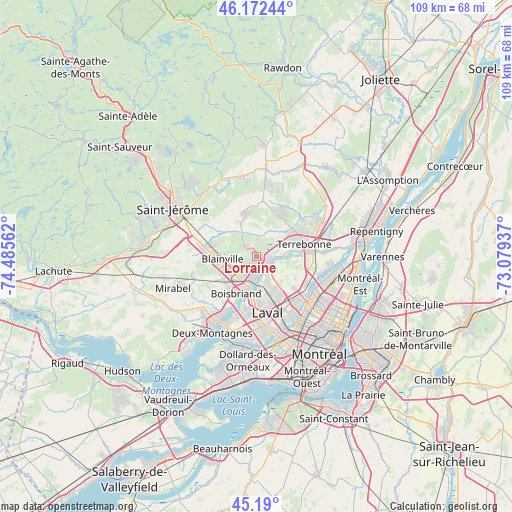
Lorraine GPS coordinates[2]
45° 41' 0.168" North, 73° 46' 56.964" West
| Map corner | latitude | longitude |
|---|---|---|
| Upper-left | 46.17244°, | -74.48562° |
| Center: | 45.68338°, | -73.78249° |
| Lower-right: | 45.19°, | -73.07937° |
| Map W x H: | 109.2×109.2 km | = 67.9×67.9mi |
| max Lat: | 73.03752° ⇑69.6% North |
| Lorraine: | 45.68338° |
| min Lat: | ⇓30.4% South 42.05009° |
| min Long | Lorraine | max Long |
| -139.43328° | -73.78249° | -52.70931° |
| W 64.9%⇐ | ⇒35.1% E |
Elevation
Elevation of Lorraine is 64 m = 210 ft, and this is 190.4 m = 625 ft below average elevation for this country.
| Max E: |
1518 m = 4980 ft | 67.8% |
| Avg. | 254.4 m = 835 ft | |
| Lorraine | 64 m = 210 ft | |
Min E: |
-2 m = -7 ft | 32.2% |
See also: Canada elevation on elevation.city.
Geographical zone
Lorraine is located in North temperate zone (between Tropic of Cancer and the Arctic Circle). Distance of this North polar circle is 2321.7 km =1442.6 mi to North.| Distance of | km | miles | from Lorraine |
|---|---|---|---|
| North Pole | 4927.5 | 3061.8 | to North |
| Arctic Circle | 2321.7 | 1442.6 | to North |
| Tropic Cancer | 2473.6 | 1537 | to South |
| Equator | 5079.5 | 3156.3 | to South |


Nearby cities:
15 places around Lorraine: (largest is in red/bold)
• Blainville
8 km =5 mi,  256°
256°
• Bois-des-Filion
3.2 km =2 mi,  125°
125°
• Boisbriand
8.4 km =5.2 mi,  207°
207°
• Laval
14.4 km =8.9 mi,  150°
150°
• Mascouche
16 km =9.9 mi,  62°
62°
• Rosemère
5.7 km =3.5 mi,  193°
193°
• Saint-Charles
17.9 km =11.1 mi,  83°
83°
• Saint-Elzéar
9.9 km =6.2 mi, 154°
• Saint-Eustache
16.3 km =10.1 mi,  216°
216°
• Saint-Léonard
18 km =11.2 mi, 126°
• Saint-Michel
17.9 km =11.1 mi,  135°
135°
• Sainte-Anne-des-Plaines
9.3 km =5.8 mi,  345°
345°
• Sainte-Sophie
17.4 km =10.8 mi,  328°
328°
• Sainte-Thérèse
6 km =3.7 mi, 215°
• Terrebonne
10.7 km =6.6 mi, 79°
Sources, notices
• [Note1] Compared only with cities in Canada existing in our database
• [Src1] Map data: © OpenStreetMap contributors (CC-BY-SA)
• [Src2] Other city data from geonames.org with taken over terms of usage.
• [Src3] Geographical zone / Annual Mean Temperature by Robert A. Rohde @ Wikipedia
