Shaunavon geodata
Shaunavon (Saskatchewan) is a populated place; located in Canada in America/Regina (GMT-6) time zone. With population of 1,658 people, there are 822 cities with bigger population in this country. Compared to other cities in Canada, 71.7% of cities are located further ↓South; 74% of cities are located further →East and 96.4% of cities have lower elevation than Shaunavon. Note1


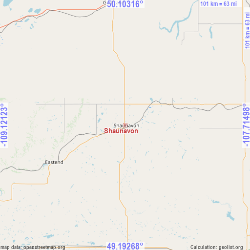
Shaunavon GPS coordinates[2]
49° 39' 0.18" North, 108° 25' 5.16" West
| Map corner | latitude | longitude |
|---|---|---|
| Upper-left | 50.10316°, | -109.12123° |
| Center: | 49.65005°, | -108.4181° |
| Lower-right: | 49.19268°, | -107.71498° |
| Map W x H: | 101.2×101.2 km | = 62.9×62.9mi |
| max Lat: | 73.03752° ⇑28.3% North |
| Shaunavon: | 49.65005° |
| min Lat: | ⇓71.7% South 42.05009° |
| min Long | Shaunavon | max Long |
| -139.43328° | -108.4181° | -52.70931° |
| W 26%⇐ | ⇒74% E |
Elevation
Elevation of Shaunavon is 916 m = 3005 ft, and this is 661.6 m = 2171 ft above average elevation for this country.
| Max E: |
1518 m = 4980 ft | 3.6% |
| Shaunavon | 916 m 3005 ft | |
| Avg. | 254.4 m = 835 ft | |
Min E: |
-2 m = -7 ft | 96.4% |
See also: Canada elevation on elevation.city.
Geographical zone
Shaunavon is located in North temperate zone (between Tropic of Cancer and the Arctic Circle). Distance of this North polar circle is 1880.6 km =1168.6 mi to North.| Distance of | km | miles | from Shaunavon |
|---|---|---|---|
| North Pole | 4486.5 | 2787.8 | to North |
| Arctic Circle | 1880.6 | 1168.6 | to North |
| Tropic Cancer | 2914.6 | 1811 | to South |
| Equator | 5520.6 | 3430.3 | to South |


Nearby cities:
15 places around Shaunavon: (largest is in red/bold)
• Assiniboia
175.2 km =108.9 mi,  90°
90°
• Bow Island
213.3 km =132.5 mi,  276°
276°
• Caronport
205.8 km =127.9 mi,  64°
64°
• Davidson
249 km =154.7 mi,  43°
43°
• Eston
168.5 km =104.7 mi,  351°
351°
• Gravelbourg
136.6 km =84.9 mi,  79°
79°
• Gull Lake
50.3 km =31.3 mi, 354°
• Kerrobert
257 km =159.7 mi, 348°
• Kindersley
208.8 km =129.7 mi, 345°
• Maple Creek
82.1 km =51 mi,  291°
291°
• Medicine Hat
167.6 km =104.1 mi, 284°
• Moose Jaw
222.2 km =138.1 mi,  67°
67°
• Outlook
227.2 km =141.2 mi,  25°
25°
• Rosetown
213.3 km =132.5 mi,  7°
7°
• Swift Current
83.1 km =51.6 mi, 32°
Sources, notices
• [Note1] Compared only with cities in Canada existing in our database
• [Src1] Map data: © OpenStreetMap contributors (CC-BY-SA)
• [Src2] Other city data from geonames.org with taken over terms of usage.
• [Src3] Geographical zone / Annual Mean Temperature by Robert A. Rohde @ Wikipedia
