Maple Creek geodata
Maple Creek (Saskatchewan) is a populated place; located in Canada in America/Regina (GMT-6) time zone. With population of 2,121 people, there are 730 cities with bigger population in this country. Compared to other cities in Canada, 75.1% of cities are located further ↓South; 74.7% of cities are located further →East and 94.1% of cities have lower elevation than Maple Creek. Note1


Maple Creek GPS coordinates[2]
49° 55' 0.408" North, 109° 29' 5.316" West
| Map corner | latitude | longitude |
|---|---|---|
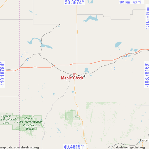
| Upper-left | 50.3674°, | -110.18794° |
| Center: | 49.91678°, | -109.48481° |
| Lower-right: | 49.46191°, | -108.78169° |
| Map W x H: | 100.7×100.7 km | = 62.6×62.6mi |
| max Lat: | 73.03752° ⇑24.9% North |
| Maple Creek: | 49.91678° |
| min Lat: | ⇓75.1% South 42.05009° |
| min Long | Maple Creek | max Long |
| -139.43328° | -109.48481° | -52.70931° |
| W 25.3%⇐ | ⇒74.7% E |
Elevation
Elevation of Maple Creek is 759 m = 2490 ft, and this is 504.6 m = 1656 ft above average elevation for this country.
| Max E: |
1518 m = 4980 ft | 5.9% |
| Maple Creek | 759 m 2490 ft | |
| Avg. | 254.4 m = 835 ft | |
Min E: |
-2 m = -7 ft | 94.1% |
See also: Canada elevation on elevation.city.
Geographical zone
Maple Creek is located in North temperate zone (between Tropic of Cancer and the Arctic Circle). Distance of this North polar circle is 1850.9 km =1150.1 mi to North.| Distance of | km | miles | from Maple Creek |
|---|---|---|---|
| North Pole | 4456.8 | 2769.3 | to North |
| Arctic Circle | 1850.9 | 1150.1 | to North |
| Tropic Cancer | 2944.3 | 1829.5 | to South |
| Equator | 5550.2 | 3448.7 | to South |


Nearby cities:
15 places around Maple Creek: (largest is in red/bold)
• Bassano
232.6 km =144.5 mi,  294°
294°
• Bow Island
135 km =83.9 mi,  267°
267°
• Brooks
186 km =115.6 mi, 293°
• Coaldale
225.9 km =140.4 mi,  264°
264°
• Eston
146.6 km =91.1 mi,  20°
20°
• Gravelbourg
210.1 km =130.6 mi,  91°
91°
• Gull Lake
74.3 km =46.2 mi,  74°
74°
• Kerrobert
223.7 km =139 mi,  6°
6°
• Kindersley
173.8 km =108 mi, 7°
• Medicine Hat
86.3 km =53.6 mi,  279°
279°
• Rosetown
209.5 km =130.2 mi,  29°
29°
• Shaunavon
82.1 km =51 mi,  111°
111°
• Swift Current
126.8 km =78.8 mi, 71°
• Taber
191.3 km =118.9 mi, 265°
• Vauxhall
189 km =117.4 mi, 275°
Sources, notices
• [Note1] Compared only with cities in Canada existing in our database
• [Src1] Map data: © OpenStreetMap contributors (CC-BY-SA)
• [Src2] Other city data from geonames.org with taken over terms of usage.
• [Src3] Geographical zone / Annual Mean Temperature by Robert A. Rohde @ Wikipedia
