Bow Island geodata
Bow Island (Alberta) is a populated place; located in Canada in America/Edmonton (GMT-6) time zone. With population of 2,025 people, there are 747 cities with bigger population in this country. Compared to other cities in Canada, 74.4% of cities are located further ↓South; 75.8% of cities are located further →East and 94.6% of cities have lower elevation than Bow Island. Note1


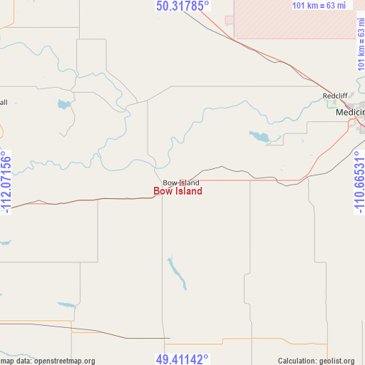
Bow Island GPS coordinates[2]
49° 52' 0.336" North, 111° 22' 6.348" West
| Map corner | latitude | longitude |
|---|---|---|
| Upper-left | 50.31785°, | -112.07156° |
| Center: | 49.86676°, | -111.36843° |
| Lower-right: | 49.41142°, | -110.66531° |
| Map W x H: | 100.8×100.8 km | = 62.6×62.6mi |
| max Lat: | 73.03752° ⇑25.6% North |
| Bow Island: | 49.86676° |
| min Lat: | ⇓74.4% South 42.05009° |
| min Long | Bow Island | max Long |
| -139.43328° | -111.36843° | -52.70931° |
| W 24.2%⇐ | ⇒75.8% E |
Elevation
Elevation of Bow Island is 795 m = 2608 ft, and this is 540.6 m = 1774 ft above average elevation for this country.
| Max E: |
1518 m = 4980 ft | 5.4% |
| Bow Island | 795 m 2608 ft | |
| Avg. | 254.4 m = 835 ft | |
Min E: |
-2 m = -7 ft | 94.6% |
See also: Canada elevation on elevation.city.
Geographical zone
Bow Island is located in North temperate zone (between Tropic of Cancer and the Arctic Circle). Distance of this North polar circle is 1856.5 km =1153.6 mi to North.| Distance of | km | miles | from Bow Island |
|---|---|---|---|
| North Pole | 4462.4 | 2772.8 | to North |
| Arctic Circle | 1856.5 | 1153.6 | to North |
| Tropic Cancer | 2938.7 | 1826 | to South |
| Equator | 5544.7 | 3445.3 | to South |


Nearby cities:
15 places around Bow Island: (largest is in red/bold)
• Bassano
128.4 km =79.8 mi,  322°
322°
• Brooks
87.8 km =54.6 mi,  335°
335°
• Cardston
158 km =98.2 mi,  242°
242°
• Coaldale
91.3 km =56.7 mi,  259°
259°
• Coalhurst
113 km =70.2 mi, 263°
• Fort Macleod
148.1 km =92 mi, 263°
• Lethbridge
105.7 km =65.7 mi, 259°
• Magrath
119 km =73.9 mi,  245°
245°
• Maple Creek
135 km =83.9 mi,  87°
87°
• Medicine Hat
53.1 km =33 mi,  68°
68°
• Picture Butte
101.5 km =63.1 mi,  271°
271°
• Raymond
103.3 km =64.2 mi, 243°
• Taber
56.5 km =35.1 mi, 260°
• Vauxhall
58.1 km =36.1 mi,  292°
292°
• Vulcan
146.7 km =91.2 mi, 293°
Sources, notices
• [Note1] Compared only with cities in Canada existing in our database
• [Src1] Map data: © OpenStreetMap contributors (CC-BY-SA)
• [Src2] Other city data from geonames.org with taken over terms of usage.
• [Src3] Geographical zone / Annual Mean Temperature by Robert A. Rohde @ Wikipedia
