Rock Island geodata
Rock Island (Quebec) is a populated place; located in Canada in America/Toronto (GMT-4) time zone. With population of 897 people, there are 1077 cities with bigger population in this country. Compared to other cities in Canada, 84.8% of cities are located further ↑North; 76.2% of cities are located further ←West and 71.2% of cities have lower elevation than Rock Island. Note1


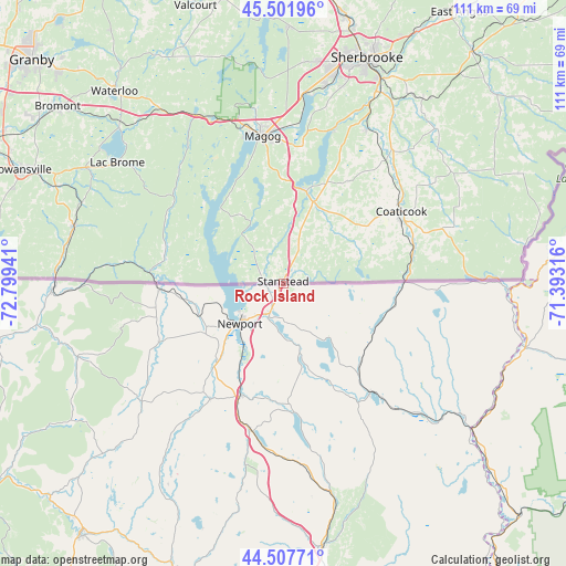
Rock Island GPS coordinates[2]
45° 0' 25.164" North, 72° 5' 46.608" West
| Map corner | latitude | longitude |
|---|---|---|
| Upper-left | 45.50196°, | -72.79941° |
| Center: | 45.00699°, | -72.09628° |
| Lower-right: | 44.50771°, | -71.39316° |
| Map W x H: | 110.6×110.5 km | = 68.7×68.7mi |
| max Lat: | 73.03752° ⇑84.8% North |
| Rock Island: | 45.00699° |
| min Lat: | ⇓15.2% South 42.05009° |
| min Long | Rock Island | max Long |
| -139.43328° | -72.09628° | -52.70931° |
| W 76.2%⇐ | ⇒23.8% E |
Elevation
Elevation of Rock Island is 314 m = 1030 ft, and this is 59.6 m = 196 ft above average elevation for this country.
| Max E: |
1518 m = 4980 ft | 28.8% |
| Rock Island | 314 m 1030 ft | |
| Avg. | 254.4 m = 835 ft | |
Min E: |
-2 m = -7 ft | 71.2% |
See also: Canada elevation on elevation.city.
Geographical zone
Rock Island is located in North temperate zone (between Tropic of Cancer and the Arctic Circle). Distance of this North polar circle is 2396.9 km =1489.4 mi to North.| Distance of | km | miles | from Rock Island |
|---|---|---|---|
| North Pole | 5002.8 | 3108.6 | to North |
| Arctic Circle | 2396.9 | 1489.4 | to North |
| Tropic Cancer | 2398.4 | 1490.3 | to South |
| Equator | 5004.3 | 3109.5 | to South |


Nearby cities:
15 places around Rock Island: (largest is in red/bold)
• Bromont
55.4 km =34.4 mi,  308°
308°
• Coaticook
27.2 km =16.9 mi,  58°
58°
• Cookshire
58.3 km =36.2 mi,  38°
38°
• Cookshire-Eaton
58.3 km =36.2 mi, 38°
• Cowansville
55.6 km =34.5 mi,  292°
292°
• Dunham
57 km =35.4 mi,  284°
284°
• Lac-Brome
40.3 km =25 mi, 305°
• Magog
29.2 km =18.1 mi,  351°
351°
• Rock Forest
39.7 km =24.7 mi,  11°
11°
• Sainte-Croix
57.1 km =35.5 mi, 284°
• Sherbrooke
46.4 km =28.8 mi,  19°
19°
• Sutton
42.1 km =26.2 mi, 284°
• Valcourt
57.5 km =35.7 mi,  342°
342°
• Waterloo
50.4 km =31.3 mi,  319°
319°
• Windsor
62.7 km =39 mi, 6°
Sources, notices
• [Note1] Compared only with cities in Canada existing in our database
• [Src1] Map data: © OpenStreetMap contributors (CC-BY-SA)
• [Src2] Other city data from geonames.org with taken over terms of usage.
• [Src3] Geographical zone / Annual Mean Temperature by Robert A. Rohde @ Wikipedia
