Strathmore geodata
Strathmore (Alberta) is a populated place; located in Canada in America/Edmonton (GMT-6) time zone. With population of 13,592 people, there are 259 cities with bigger population in this country. Compared to other cities in Canada, 82.3% of cities are located further ↓South; 79% of cities are located further →East and 97.1% of cities have lower elevation than Strathmore. Note1


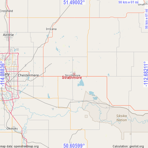
Strathmore GPS coordinates[2]
51° 3' 0.396" North, 113° 23' 6.828" West
| Map corner | latitude | longitude |
|---|---|---|
| Upper-left | 51.49002°, | -114.08836° |
| Center: | 51.05011°, | -113.38523° |
| Lower-right: | 50.60599°, | -112.68211° |
| Map W x H: | 98.3×98.3 km | = 61.1×61.1mi |
| max Lat: | 73.03752° ⇑17.7% North |
| Strathmore: | 51.05011° |
| min Lat: | ⇓82.3% South 42.05009° |
| min Long | Strathmore | max Long |
| -139.43328° | -113.38523° | -52.70931° |
| W 21%⇐ | ⇒79% E |
Elevation
Elevation of Strathmore is 976 m = 3202 ft, and this is 721.6 m = 2367 ft above average elevation for this country.
| Max E: |
1518 m = 4980 ft | 2.9% |
| Strathmore | 976 m 3202 ft | |
| Avg. | 254.4 m = 835 ft | |
Min E: |
-2 m = -7 ft | 97.1% |
See also: Canada elevation on elevation.city.
Geographical zone
Strathmore is located in North temperate zone (between Tropic of Cancer and the Arctic Circle). Distance of this North polar circle is 1724.9 km =1071.8 mi to North.| Distance of | km | miles | from Strathmore |
|---|---|---|---|
| North Pole | 4330.8 | 2691 | to North |
| Arctic Circle | 1724.9 | 1071.8 | to North |
| Tropic Cancer | 3070.3 | 1907.8 | to South |
| Equator | 5676.2 | 3527 | to South |


Nearby cities:
15 places around Strathmore: (largest is in red/bold)
• Airdrie
53.2 km =33.1 mi,  301°
301°
• Bassano
70.8 km =44 mi,  114°
114°
• Black Diamond
71.2 km =44.2 mi,  236°
236°
• Calgary
48.9 km =30.4 mi,  270°
270°
• Carstairs
76 km =47.2 mi,  319°
319°
• Chestermere
30.4 km =18.9 mi, 266°
• Cochrane
77.1 km =47.9 mi,  281°
281°
• Crossfield
62.2 km =38.6 mi,  313°
313°
• Heritage Pointe
49.2 km =30.6 mi, 241°
• High River
62 km =38.5 mi,  213°
213°
• Irricana
34.1 km =21.2 mi,  333°
333°
• Nanton
82.4 km =51.2 mi,  199°
199°
• Okotoks
55.1 km =34.2 mi,  229°
229°
• Three Hills
72.7 km =45.2 mi,  6°
6°
• Vulcan
72.9 km =45.3 mi,  172°
172°
Sources, notices
• [Note1] Compared only with cities in Canada existing in our database
• [Src1] Map data: © OpenStreetMap contributors (CC-BY-SA)
• [Src2] Other city data from geonames.org with taken over terms of usage.
• [Src3] Geographical zone / Annual Mean Temperature by Robert A. Rohde @ Wikipedia
