Vulcan geodata
Vulcan (Alberta) is a populated place; located in Canada in America/Edmonton (GMT-6) time zone. With population of 1,853 people, there are 780 cities with bigger population in this country. Compared to other cities in Canada, 78.6% of cities are located further ↓South; 77.9% of cities are located further →East and 98.3% of cities have lower elevation than Vulcan. Note1


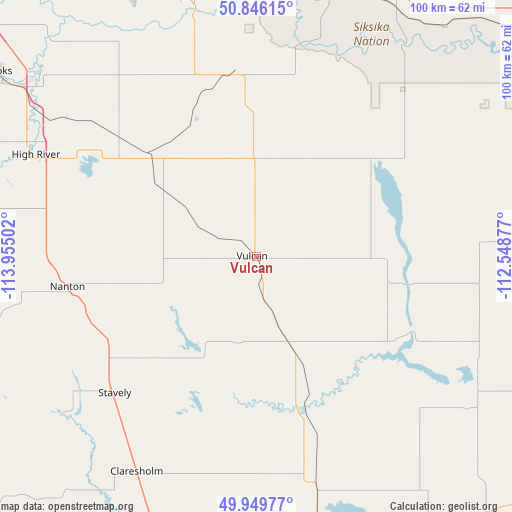
Vulcan GPS coordinates[2]
50° 24' 0.288" North, 113° 15' 6.804" West
| Map corner | latitude | longitude |
|---|---|---|
| Upper-left | 50.84615°, | -113.95502° |
| Center: | 50.40008°, | -113.25189° |
| Lower-right: | 49.94977°, | -112.54877° |
| Map W x H: | 99.7×99.7 km | = 62×62mi |
| max Lat: | 73.03752° ⇑21.4% North |
| Vulcan: | 50.40008° |
| min Lat: | ⇓78.6% South 42.05009° |
| min Long | Vulcan | max Long |
| -139.43328° | -113.25189° | -52.70931° |
| W 22.1%⇐ | ⇒77.9% E |
Elevation
Elevation of Vulcan is 1043 m = 3422 ft, and this is 788.6 m = 2587 ft above average elevation for this country.
| Max E: |
1518 m = 4980 ft | 1.7% |
| Vulcan | 1043 m 3422 ft | |
| Avg. | 254.4 m = 835 ft | |
Min E: |
-2 m = -7 ft | 98.3% |
See also: Canada elevation on elevation.city.
Geographical zone
Vulcan is located in North temperate zone (between Tropic of Cancer and the Arctic Circle). Distance of this North polar circle is 1797.2 km =1116.7 mi to North.| Distance of | km | miles | from Vulcan |
|---|---|---|---|
| North Pole | 4403.1 | 2736 | to North |
| Arctic Circle | 1797.2 | 1116.7 | to North |
| Tropic Cancer | 2998 | 1862.9 | to South |
| Equator | 5604 | 3482.2 | to South |


Nearby cities:
15 places around Vulcan: (largest is in red/bold)
• Bassano
69.8 km =43.4 mi,  52°
52°
• Black Diamond
77.1 km =47.9 mi,  295°
295°
• Chestermere
80.9 km =50.3 mi,  330°
330°
• Claresholm
47.2 km =29.3 mi,  210°
210°
• Coaldale
88.4 km =54.9 mi,  149°
149°
• Coalhurst
76.2 km =47.3 mi,  162°
162°
• Fort Macleod
76.9 km =47.8 mi,  188°
188°
• Heritage Pointe
72.4 km =45 mi,  312°
312°
• High River
48.2 km =30 mi, 295°
• Lethbridge
83.8 km =52.1 mi, 158°
• Nanton
37.1 km =23.1 mi,  261°
261°
• Okotoks
63.3 km =39.3 mi, 305°
• Picture Butte
66.4 km =41.3 mi, 149°
• Strathmore
72.9 km =45.3 mi,  352°
352°
• Vauxhall
88.7 km =55.1 mi,  114°
114°
Sources, notices
• [Note1] Compared only with cities in Canada existing in our database
• [Src1] Map data: © OpenStreetMap contributors (CC-BY-SA)
• [Src2] Other city data from geonames.org with taken over terms of usage.
• [Src3] Geographical zone / Annual Mean Temperature by Robert A. Rohde @ Wikipedia
