East Gwillimbury geodata
East Gwillimbury (Ontario) is a populated place; located in Canada in America/Toronto (GMT-4) time zone. With population of 23,991 people, there are 166 cities with bigger population in this country. Compared to other cities in Canada, 90.8% of cities are located further ↑North; 52.9% of cities are located further →East and 64.9% of cities have lower elevation than East Gwillimbury. Note1


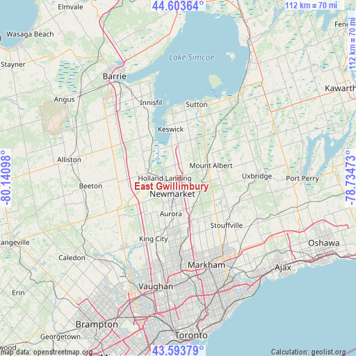
East Gwillimbury GPS coordinates[2]
44° 6' 3.132" North, 79° 26' 16.26" West
| Map corner | latitude | longitude |
|---|---|---|
| Upper-left | 44.60364°, | -80.14098° |
| Center: | 44.10087°, | -79.43785° |
| Lower-right: | 43.59379°, | -78.73473° |
| Map W x H: | 112.3×112.3 km | = 69.8×69.8mi |
| max Lat: | 73.03752° ⇑90.8% North |
| East Gwillimbury: | 44.10087° |
| min Lat: | ⇓9.2% South 42.05009° |
| min Long | East Gwillimbur | max Long |
| -139.43328° | -79.43785° | -52.70931° |
| W 47.1%⇐ | ⇒52.9% E |
Elevation
Elevation of East Gwillimbury is 256 m = 840 ft, and this is 1.6 m = 5 ft above average elevation for this country.
| Max E: |
1518 m = 4980 ft | 35.1% |
| East Gwillimbury | 256 m 840 ft | |
| Avg. | 254.4 m = 835 ft | |
Min E: |
-2 m = -7 ft | 64.9% |
See also: Canada elevation on elevation.city.
Geographical zone
East Gwillimbury is located in North temperate zone (between Tropic of Cancer and the Arctic Circle). Distance of this Northern Tropic circle is 2297.6 km =1427.7 mi to South.| Distance of | km | miles | from East Gwillimbury |
|---|---|---|---|
| North Pole | 5103.5 | 3171.2 | to North |
| Arctic Circle | 2497.6 | 1551.9 | to North |
| Tropic Cancer | 2297.6 | 1427.7 | to South |
| Equator | 4903.6 | 3047 | to South |


Nearby cities:
15 places around East Gwillimbury: (largest is in red/bold)
• Aurora
11.4 km =7.1 mi,  191°
191°
• Ballantrae
13.4 km =8.3 mi,  124°
124°
• Cookstown
22.8 km =14.2 mi,  293°
293°
• Goodwood
20.5 km =12.7 mi,  111°
111°
• Innisfil
27.9 km =17.3 mi,  322°
322°
• Keswick
16.7 km =10.4 mi,  352°
352°
• King
19.4 km =12.1 mi,  218°
218°
• Markham
29.4 km =18.3 mi,  152°
152°
• Mount Albert
10.4 km =6.5 mi,  69°
69°
• Newmarket
6.1 km =3.8 mi,  201°
201°
• Richmond Hill
25.5 km =15.8 mi,  179°
179°
• Stoney Point
19.9 km =12.4 mi,  337°
337°
• Uxbridge
25.7 km =16 mi,  90°
90°
• Vaughan
29.8 km =18.5 mi, 189°
• Zephyr
17.6 km =10.9 mi,  51°
51°
Sources, notices
• [Note1] Compared only with cities in Canada existing in our database
• [Src1] Map data: © OpenStreetMap contributors (CC-BY-SA)
• [Src2] Other city data from geonames.org with taken over terms of usage.
• [Src3] Geographical zone / Annual Mean Temperature by Robert A. Rohde @ Wikipedia
