Ballantrae geodata
Ballantrae (Ontario) is a populated place; located in Canada in America/Toronto (GMT-4) time zone. With population of 3,223 people, there are 590 cities with bigger population in this country. Compared to other cities in Canada, 91.5% of cities are located further ↑North; 51.4% of cities are located further →East and 73.1% of cities have lower elevation than Ballantrae. Note1


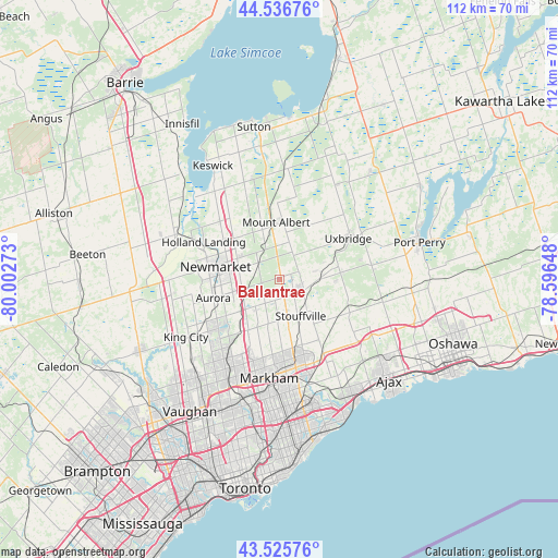
Ballantrae GPS coordinates[2]
44° 2' 0.312" North, 79° 17' 58.56" West
| Map corner | latitude | longitude |
|---|---|---|
| Upper-left | 44.53676°, | -80.00273° |
| Center: | 44.03342°, | -79.2996° |
| Lower-right: | 43.52576°, | -78.59648° |
| Map W x H: | 112.4×112.4 km | = 69.8×69.8mi |
| max Lat: | 73.03752° ⇑91.5% North |
| Ballantrae: | 44.03342° |
| min Lat: | ⇓8.5% South 42.05009° |
| min Long | Ballantrae | max Long |
| -139.43328° | -79.2996° | -52.70931° |
| W 48.6%⇐ | ⇒51.4% E |
Elevation
Elevation of Ballantrae is 338 m = 1109 ft, and this is 83.6 m = 274 ft above average elevation for this country.
| Max E: |
1518 m = 4980 ft | 26.9% |
| Ballantrae | 338 m 1109 ft | |
| Avg. | 254.4 m = 835 ft | |
Min E: |
-2 m = -7 ft | 73.1% |
See also: Canada elevation on elevation.city.
Geographical zone
Ballantrae is located in North temperate zone (between Tropic of Cancer and the Arctic Circle). Distance of this Northern Tropic circle is 2290.1 km =1423 mi to South.| Distance of | km | miles | from Ballantrae |
|---|---|---|---|
| North Pole | 5111 | 3175.8 | to North |
| Arctic Circle | 2505.1 | 1556.6 | to North |
| Tropic Cancer | 2290.1 | 1423 | to South |
| Equator | 4896.1 | 3042.3 | to South |


Nearby cities:
15 places around Ballantrae: (largest is in red/bold)
• Aurora
13.8 km =8.6 mi,  254°
254°
• East Gwillimbury
13.4 km =8.3 mi,  304°
304°
• Goodwood
8 km =5 mi,  90°
90°
• Greenbank
26.1 km =16.2 mi,  60°
60°
• Keswick
27.5 km =17.1 mi,  331°
331°
• King
24.4 km =15.2 mi, 251°
• Markham
18.7 km =11.6 mi,  171°
171°
• Mount Albert
11.2 km =7 mi,  353°
353°
• Newmarket
13.5 km =8.4 mi,  277°
277°
• Pickering
19.9 km =12.4 mi,  138°
138°
• Richmond Hill
21.1 km =13.1 mi,  211°
211°
• Scarborough
29.2 km =18.1 mi, 173°
• Uxbridge
16.4 km =10.2 mi, 63°
• Vaughan
27.1 km =16.8 mi,  215°
215°
• Zephyr
18.7 km =11.6 mi,  8°
8°
Sources, notices
• [Note1] Compared only with cities in Canada existing in our database
• [Src1] Map data: © OpenStreetMap contributors (CC-BY-SA)
• [Src2] Other city data from geonames.org with taken over terms of usage.
• [Src3] Geographical zone / Annual Mean Temperature by Robert A. Rohde @ Wikipedia
