Yarmouth geodata
Yarmouth (Nova Scotia) is a populated place; located in Canada in America/Halifax (GMT-3) time zone. With population of 7,500 people, there are 383 cities with bigger population in this country. Compared to other cities in Canada, 92.9% of cities are located further ↑North; 87.7% of cities are located further ←West and 83.4% of cities have higher elevation than Yarmouth. Note1


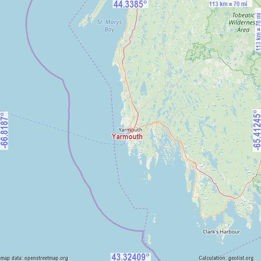
Yarmouth GPS coordinates[2]
43° 50' 0.42" North, 66° 6' 56.052" West
| Map corner | latitude | longitude |
|---|---|---|
| Upper-left | 44.3385°, | -66.8187° |
| Center: | 43.83345°, | -66.11557° |
| Lower-right: | 43.32409°, | -65.41245° |
| Map W x H: | 112.8×112.8 km | = 70.1×70.1mi |
| max Lat: | 73.03752° ⇑92.9% North |
| Yarmouth: | 43.83345° |
| min Lat: | ⇓7.1% South 42.05009° |
| min Long | Yarmouth | max Long |
| -139.43328° | -66.11557° | -52.70931° |
| W 87.7%⇐ | ⇒12.3% E |
Elevation
Elevation of Yarmouth is 26 m = 85 ft, and this is 228.4 m = 749 ft below average elevation for this country.
| Max E: |
1518 m = 4980 ft | 83.4% |
| Avg. | 254.4 m = 835 ft | |
| Yarmouth | 26 m = 85 ft | |
Min E: |
-2 m = -7 ft | 16.6% |
See also: Canada elevation on elevation.city.
Geographical zone
Yarmouth is located in North temperate zone (between Tropic of Cancer and the Arctic Circle). Distance of this Northern Tropic circle is 2267.9 km =1409.2 mi to South.| Distance of | km | miles | from Yarmouth |
|---|---|---|---|
| North Pole | 5133.2 | 3189.6 | to North |
| Arctic Circle | 2527.4 | 1570.5 | to North |
| Tropic Cancer | 2267.9 | 1409.2 | to South |
| Equator | 4873.8 | 3028.4 | to South |


Nearby cities:
15 places around Yarmouth: (largest is in red/bold)
• Berwick
174.2 km =108.2 mi,  39°
39°
• Bridgewater
141.2 km =87.7 mi,  64°
64°
• Chester
169.1 km =105.1 mi, 62°
• Digby
92.2 km =57.3 mi,  17°
17°
• Fundy Bay
113.2 km =70.3 mi,  333°
333°
• Greenwood
157.9 km =98.1 mi, 36°
• Hampton
189.6 km =117.8 mi,  6°
6°
• Hayes Subdivision
182.1 km =113.2 mi, 41°
• Kentville
188.8 km =117.3 mi, 42°
• Lunenburg
155.9 km =96.9 mi,  67°
67°
• Middleton
148.7 km =92.4 mi,  33°
33°
• Saint Andrews
156.7 km =97.4 mi, 331°
• Saint John
160.1 km =99.5 mi,  1°
1°
• Shelburne
64 km =39.8 mi,  97°
97°
• Wells
174 km =108.1 mi, 5°
Sources, notices
• [Note1] Compared only with cities in Canada existing in our database
• [Src1] Map data: © OpenStreetMap contributors (CC-BY-SA)
• [Src2] Other city data from geonames.org with taken over terms of usage.
• [Src3] Geographical zone / Annual Mean Temperature by Robert A. Rohde @ Wikipedia
