Zephyr geodata
Zephyr (Ontario) is a populated place; located in Canada in America/Toronto (GMT-4) time zone. With population of 505 people, there are 1175 cities with bigger population in this country. Compared to other cities in Canada, 89.8% of cities are located further ↑North; 51.3% of cities are located further →East and 63.8% of cities have lower elevation than Zephyr. Note1


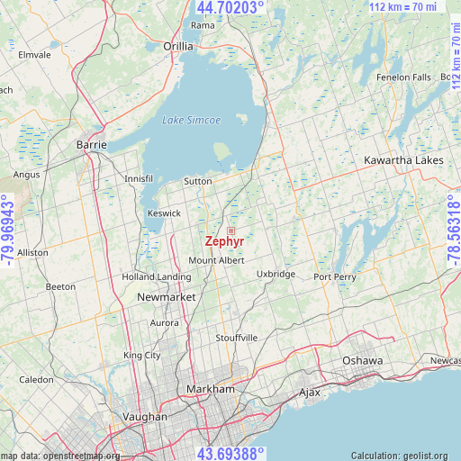
Zephyr GPS coordinates[2]
44° 12' 0.396" North, 79° 15' 58.68" West
| Map corner | latitude | longitude |
|---|---|---|
| Upper-left | 44.70203°, | -79.96943° |
| Center: | 44.20011°, | -79.2663° |
| Lower-right: | 43.69388°, | -78.56318° |
| Map W x H: | 112.1×112.1 km | = 69.7×69.7mi |
| max Lat: | 73.03752° ⇑89.8% North |
| Zephyr: | 44.20011° |
| min Lat: | ⇓10.2% South 42.05009° |
| min Long | Zephyr | max Long |
| -139.43328° | -79.2663° | -52.70931° |
| W 48.7%⇐ | ⇒51.3% E |
Elevation
Elevation of Zephyr is 250 m = 820 ft, and this is 4.4 m = 14 ft below average elevation for this country.
| Max E: |
1518 m = 4980 ft | 36.2% |
| Avg. | 254.4 m = 835 ft | |
| Zephyr | 250 m = 820 ft | |
Min E: |
-2 m = -7 ft | 63.8% |
See also: Canada elevation on elevation.city.
Geographical zone
Zephyr is located in North temperate zone (between Tropic of Cancer and the Arctic Circle). Distance of this Northern Tropic circle is 2308.7 km =1434.6 mi to South.| Distance of | km | miles | from Zephyr |
|---|---|---|---|
| North Pole | 5092.5 | 3164.3 | to North |
| Arctic Circle | 2486.6 | 1545.1 | to North |
| Tropic Cancer | 2308.7 | 1434.6 | to South |
| Equator | 4914.6 | 3053.8 | to South |


Nearby cities:
15 places around Zephyr: (largest is in red/bold)
• Aurora
27.4 km =17 mi,  215°
215°
• Ballantrae
18.7 km =11.6 mi,  188°
188°
• Caesarea
35 km =21.7 mi,  99°
99°
• Cookstown
34.6 km =21.5 mi,  266°
266°
• East Gwillimbury
17.6 km =10.9 mi,  231°
231°
• Goodwood
19.3 km =12 mi,  163°
163°
• Greenbank
20.7 km =12.9 mi,  105°
105°
• Innisfil
32.5 km =20.2 mi,  290°
290°
• Keswick
16.9 km =10.5 mi, 289°
• King
36.8 km =22.9 mi, 224°
• Mount Albert
8.4 km =5.2 mi,  208°
208°
• Newmarket
23.1 km =14.4 mi, 223°
• Pickering
35 km =21.7 mi, 162°
• Stoney Point
22.5 km =14 mi, 289°
• Uxbridge
16.3 km =10.1 mi,  132°
132°
Sources, notices
• [Note1] Compared only with cities in Canada existing in our database
• [Src1] Map data: © OpenStreetMap contributors (CC-BY-SA)
• [Src2] Other city data from geonames.org with taken over terms of usage.
• [Src3] Geographical zone / Annual Mean Temperature by Robert A. Rohde @ Wikipedia
