Keswick geodata
Keswick (Ontario) is a section of populated place; located in Canada in America/Toronto (GMT-4) time zone. With population of 21,000 people, there are 180 cities with bigger population in this country. Compared to other cities in Canada, 89.5% of cities are located further ↑North; 53.2% of cities are located further →East and 59.5% of cities have lower elevation than Keswick. Note1


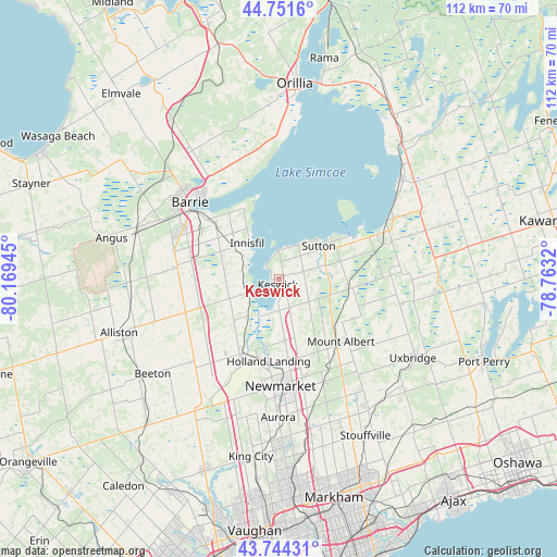
Keswick GPS coordinates[2]
44° 15' 0.396" North, 79° 27' 58.752" West
| Map corner | latitude | longitude |
|---|---|---|
| Upper-left | 44.7516°, | -80.16945° |
| Center: | 44.25011°, | -79.46632° |
| Lower-right: | 43.74431°, | -78.7632° |
| Map W x H: | 112×112 km | = 69.6×69.6mi |
| max Lat: | 73.03752° ⇑89.5% North |
| Keswick: | 44.25011° |
| min Lat: | ⇓10.5% South 42.05009° |
| min Long | Keswick | max Long |
| -139.43328° | -79.46632° | -52.70931° |
| W 46.8%⇐ | ⇒53.2% E |
Elevation
Elevation of Keswick is 230 m = 755 ft, and this is 24.4 m = 80 ft below average elevation for this country.
| Max E: |
1518 m = 4980 ft | 40.5% |
| Avg. | 254.4 m = 835 ft | |
| Keswick | 230 m = 755 ft | |
Min E: |
-2 m = -7 ft | 59.5% |
See also: Canada elevation on elevation.city.
Geographical zone
Keswick is located in North temperate zone (between Tropic of Cancer and the Arctic Circle). Distance of this Northern Tropic circle is 2314.2 km =1438 mi to South.| Distance of | km | miles | from Keswick |
|---|---|---|---|
| North Pole | 5086.9 | 3160.9 | to North |
| Arctic Circle | 2481 | 1541.6 | to North |
| Tropic Cancer | 2314.2 | 1438 | to South |
| Equator | 4920.2 | 3057.3 | to South |


Nearby cities:
15 places around Keswick: (largest is in red/bold)
• Alliston
33.8 km =21 mi,  250°
250°
• Angus
34 km =21.1 mi,  282°
282°
• Aurora
27.8 km =17.3 mi,  180°
180°
• Ballantrae
27.5 km =17.1 mi,  151°
151°
• Barrie
23.1 km =14.4 mi,  316°
316°
• Cookstown
20 km =12.4 mi, 248°
• East Gwillimbury
16.7 km =10.4 mi,  172°
172°
• Goodwood
32.1 km =19.9 mi,  138°
138°
• Innisfil
15.6 km =9.7 mi,  290°
290°
• King
33.2 km =20.6 mi,  197°
197°
• Mount Albert
17.6 km =10.9 mi, 137°
• Newmarket
22.2 km =13.8 mi, 179°
• Stoney Point
5.6 km =3.5 mi, 289°
• Uxbridge
32.5 km =20.2 mi,  120°
120°
• Zephyr
16.9 km =10.5 mi,  109°
109°
Sources, notices
• [Note1] Compared only with cities in Canada existing in our database
• [Src1] Map data: © OpenStreetMap contributors (CC-BY-SA)
• [Src2] Other city data from geonames.org with taken over terms of usage.
• [Src3] Geographical zone / Annual Mean Temperature by Robert A. Rohde @ Wikipedia
