Saint-Anselme geodata
Saint-Anselme (Quebec) is a populated place; located in Canada in America/Toronto (GMT-4) time zone. With population of 2,541 people, there are 667 cities with bigger population in this country. Compared to other cities in Canada, 54.6% of cities are located further ↑North; 81.2% of cities are located further ←West and 51% of cities have higher elevation than Saint-Anselme. Note1


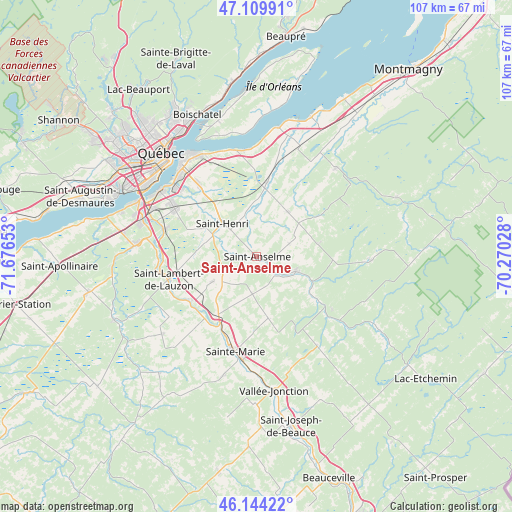
Saint-Anselme GPS coordinates[2]
46° 37' 45.192" North, 70° 58' 24.24" West
| Map corner | latitude | longitude |
|---|---|---|
| Upper-left | 47.10991°, | -71.67653° |
| Center: | 46.62922°, | -70.9734° |
| Lower-right: | 46.14422°, | -70.27028° |
| Map W x H: | 107.4×107.4 km | = 66.7×66.7mi |
| max Lat: | 73.03752° ⇑54.6% North |
| Saint-Anselme: | 46.62922° |
| min Lat: | ⇓45.4% South 42.05009° |
| min Long | Saint-Anselme | max Long |
| -139.43328° | -70.9734° | -52.70931° |
| W 81.2%⇐ | ⇒18.8% E |
Elevation
Elevation of Saint-Anselme is 164 m = 538 ft, and this is 90.4 m = 297 ft below average elevation for this country.
| Max E: |
1518 m = 4980 ft | 51% |
| Avg. | 254.4 m = 835 ft | |
| Saint-Anselme | 164 m = 538 ft | |
Min E: |
-2 m = -7 ft | 49% |
See also: Canada elevation on elevation.city.
Geographical zone
Saint-Anselme is located in North temperate zone (between Tropic of Cancer and the Arctic Circle). Distance of this North polar circle is 2216.5 km =1377.3 mi to North.| Distance of | km | miles | from Saint-Anselme |
|---|---|---|---|
| North Pole | 4822.4 | 2996.5 | to North |
| Arctic Circle | 2216.5 | 1377.3 | to North |
| Tropic Cancer | 2578.8 | 1602.4 | to South |
| Equator | 5184.7 | 3221.6 | to South |


Nearby cities:
15 places around Saint-Anselme: (largest is in red/bold)
• Beaupré
46.5 km =28.9 mi,  7°
7°
• Breakeyville
19.9 km =12.4 mi,  286°
286°
• Château-Richer
37.1 km =23.1 mi,  353°
353°
• L'Ancienne-Lorette
34.2 km =21.3 mi,  302°
302°
• L'Ange-Gardien
33.4 km =20.8 mi, 345°
• La Haute-Saint-Charles
42 km =26.1 mi,  313°
313°
• Lévis
24.9 km =15.5 mi,  321°
321°
• Québec
27.4 km =17 mi, 317°
• Saint-Antoine-de-Tilly
46 km =28.6 mi,  274°
274°
• Saint-Augustin-de-Desmaures
38.5 km =23.9 mi, 288°
• Saint-Henri
10.2 km =6.3 mi, 314°
• Saint-Joseph-de-Beauce
37.5 km =23.3 mi,  167°
167°
• Saint-Lambert-de-Lauzon
18.6 km =11.6 mi,  255°
255°
• Sainte-Marie
21.9 km =13.6 mi,  187°
187°
• Vallée-Jonction
28.6 km =17.8 mi, 171°
Sources, notices
• [Note1] Compared only with cities in Canada existing in our database
• [Src1] Map data: © OpenStreetMap contributors (CC-BY-SA)
• [Src2] Other city data from geonames.org with taken over terms of usage.
• [Src3] Geographical zone / Annual Mean Temperature by Robert A. Rohde @ Wikipedia
