L'Ange-Gardien geodata
L'Ange-Gardien (Quebec) is a populated place; located in Canada in America/Toronto (GMT-4) time zone. With population of 3,634 people, there are 559 cities with bigger population in this country. Compared to other cities in Canada, 52% of cities are located further ↑North; 80.6% of cities are located further ←West and 85.9% of cities have higher elevation than L'Ange-Gardien. Note1


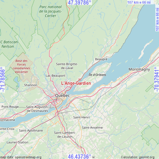
L'Ange-Gardien GPS coordinates[2]
46° 55' 11.136" North, 71° 4' 57.108" West
| Map corner | latitude | longitude |
|---|---|---|
| Upper-left | 47.39786°, | -71.78566° |
| Center: | 46.91976°, | -71.08253° |
| Lower-right: | 46.43736°, | -70.37941° |
| Map W x H: | 106.8×106.8 km | = 66.4×66.4mi |
| max Lat: | 73.03752° ⇑52% North |
| L'Ange-Gardien: | 46.91976° |
| min Lat: | ⇓48% South 42.05009° |
| min Long | L'Ange-Gardien | max Long |
| -139.43328° | -71.08253° | -52.70931° |
| W 80.6%⇐ | ⇒19.4% E |
Elevation
Elevation of L'Ange-Gardien is 20 m = 66 ft, and this is 234.4 m = 769 ft below average elevation for this country.
| Max E: |
1518 m = 4980 ft | 85.9% |
| Avg. | 254.4 m = 835 ft | |
| L'Ange-Gardien | 20 m = 66 ft | |
Min E: |
-2 m = -7 ft | 14.1% |
See also: Canada elevation on elevation.city.
Geographical zone
L'Ange-Gardien is located in North temperate zone (between Tropic of Cancer and the Arctic Circle). Distance of this North polar circle is 2184.2 km =1357.2 mi to North.| Distance of | km | miles | from L'Ange-Gardien |
|---|---|---|---|
| North Pole | 4790.1 | 2976.4 | to North |
| Arctic Circle | 2184.2 | 1357.2 | to North |
| Tropic Cancer | 2611.1 | 1622.5 | to South |
| Equator | 5217 | 3241.7 | to South |


Nearby cities:
15 places around L'Ange-Gardien: (largest is in red/bold)
• Beaupré
19.8 km =12.3 mi,  45°
45°
• Breakeyville
28.7 km =17.8 mi,  201°
201°
• Château-Richer
5.9 km =3.7 mi,  40°
40°
• Fossambault-sur-le-Lac
40.8 km =25.4 mi,  263°
263°
• L'Ancienne-Lorette
24.8 km =15.4 mi,  235°
235°
• La Haute-Saint-Charles
22.2 km =13.8 mi, 261°
• Lévis
14.8 km =9.2 mi,  209°
209°
• Montmagny
40.6 km =25.2 mi,  80°
80°
• Québec
15.6 km =9.7 mi,  220°
220°
• Saint-Anselme
33.4 km =20.8 mi,  165°
165°
• Saint-Augustin-de-Desmaures
34.4 km =21.4 mi,  234°
234°
• Saint-Henri
25.2 km =15.7 mi,  177°
177°
• Saint-Lambert-de-Lauzon
38.3 km =23.8 mi,  194°
194°
• Sainte Catherine de la Jacques Cartier
41.6 km =25.8 mi, 259°
• Shannon
33.1 km =20.6 mi, 262°
Sources, notices
• [Note1] Compared only with cities in Canada existing in our database
• [Src1] Map data: © OpenStreetMap contributors (CC-BY-SA)
• [Src2] Other city data from geonames.org with taken over terms of usage.
• [Src3] Geographical zone / Annual Mean Temperature by Robert A. Rohde @ Wikipedia
