Saint-Lambert-de-Lauzon geodata
Saint-Lambert-de-Lauzon (Quebec) is a populated place; located in Canada in America/Toronto (GMT-4) time zone. With population of 2,443 people, there are 685 cities with bigger population in this country. Compared to other cities in Canada, 55% of cities are located further ↑North; 80.4% of cities are located further ←West and 55.8% of cities have higher elevation than Saint-Lambert-de-Lauzon. Note1
Administrative division(s):
- Level 1: Quebec
- Level 2: Chaudière-Appalaches
- Level 3: Saint-Lambert-de-Lauzon
Current local time in Saint-Lambert-de-Lauzon:
05:01 AM, FridayDifference from your time zone: hours


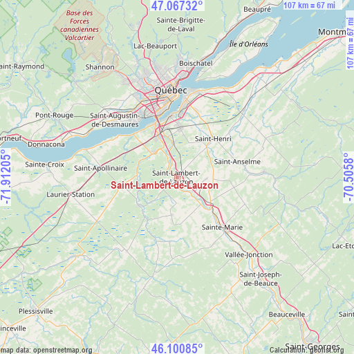
Saint-Lambert-de-Lauzon GPS coordinates[2]
46° 35' 10.464" North, 71° 12' 32.112" West
| Map corner | latitude | longitude |
|---|---|---|
| Upper-left | 47.06732°, | -71.91205° |
| Center: | 46.58624°, | -71.20892° |
| Lower-right: | 46.10085°, | -70.5058° |
| Map W x H: | 107.5×107.5 km | = 66.8×66.8mi |
| max Lat: | 73.03752° ⇑55% North |
| Saint-Lambert-de-Lauzon: | 46.58624° |
| min Lat: | ⇓45% South 42.05009° |
| min Long | Saint-Lambert-d | max Long |
| -139.43328° | -71.20892° | -52.70931° |
| W 80.4%⇐ | ⇒19.6% E |
Elevation
Elevation of Saint-Lambert-de-Lauzon is 131 m = 430 ft, and this is 123.4 m = 405 ft below average elevation for this country.
| Max E: |
1518 m = 4980 ft | 55.8% |
| Avg. | 254.4 m = 835 ft | |
| Saint-Lambert-de-Lauzon | 131 m = 430 ft | |
Min E: |
-2 m = -7 ft | 44.2% |
See also: Canada elevation on elevation.city.
Geographical zone
Saint-Lambert-de-Lauzon is located in North temperate zone (between Tropic of Cancer and the Arctic Circle). Distance of this North polar circle is 2221.3 km =1380.3 mi to North.| Distance of | km | miles | from Saint-Lambert-de-Lauzon |
|---|---|---|---|
| North Pole | 4827.2 | 2999.5 | to North |
| Arctic Circle | 2221.3 | 1380.3 | to North |
| Tropic Cancer | 2574 | 1599.4 | to South |
| Equator | 5179.9 | 3218.6 | to South |


Nearby cities:
15 places around Saint-Lambert-de-Lauzon: (largest is in red/bold)
• Breakeyville
10.5 km =6.5 mi,  354°
354°
• L'Ancienne-Lorette
25.5 km =15.8 mi,  334°
334°
• L'Ange-Gardien
38.3 km =23.8 mi,  14°
14°
• La Haute-Saint-Charles
36 km =22.4 mi,  339°
339°
• Lévis
24.2 km =15 mi, 5°
• Neuville
31.1 km =19.3 mi,  293°
293°
• Québec
25.1 km =15.6 mi,  359°
359°
• Saint-Anselme
18.6 km =11.6 mi,  75°
75°
• Saint-Antoine-de-Tilly
29.1 km =18.1 mi, 287°
• Saint-Augustin-de-Desmaures
25.2 km =15.7 mi,  312°
312°
• Saint-Flavien
30.8 km =19.1 mi,  254°
254°
• Saint-Henri
16 km =9.9 mi,  41°
41°
• Sainte-Marie
22.7 km =14.1 mi,  138°
138°
• Shannon
40.1 km =24.9 mi,  324°
324°
• Vallée-Jonction
32.4 km =20.1 mi, 136°
Sources, notices
• [Note1] Compared only with cities in Canada existing in our database
• [Src1] Map data: © OpenStreetMap contributors (CC-BY-SA)
• [Src2] Other city data from geonames.org with taken over terms of usage.
• [Src3] Geographical zone / Annual Mean Temperature by Robert A. Rohde @ Wikipedia
