Montmagny geodata
Montmagny (Quebec) is a populated place; located in Canada in America/Toronto (GMT-4) time zone. With population of 11,724 people, there are 281 cities with bigger population in this country. Compared to other cities in Canada, 51.8% of cities are located further ↑North; 82% of cities are located further ←West and 90% of cities have higher elevation than Montmagny. Note1


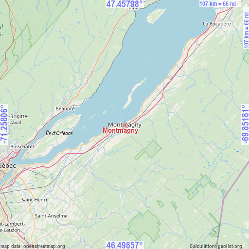
Montmagny GPS coordinates[2]
46° 58' 49.548" North, 70° 33' 17.748" West
| Map corner | latitude | longitude |
|---|---|---|
| Upper-left | 47.45798°, | -71.25806° |
| Center: | 46.98043°, | -70.55493° |
| Lower-right: | 46.49857°, | -69.85181° |
| Map W x H: | 106.7×106.7 km | = 66.3×66.3mi |
| max Lat: | 73.03752° ⇑51.8% North |
| Montmagny: | 46.98043° |
| min Lat: | ⇓48.2% South 42.05009° |
| min Long | Montmagny | max Long |
| -139.43328° | -70.55493° | -52.70931° |
| W 82%⇐ | ⇒18% E |
Elevation
Elevation of Montmagny is 15 m = 49 ft, and this is 239.4 m = 785 ft below average elevation for this country.
| Max E: |
1518 m = 4980 ft | 90% |
| Avg. | 254.4 m = 835 ft | |
| Montmagny | 15 m = 49 ft | |
Min E: |
-2 m = -7 ft | 10% |
See also: Canada elevation on elevation.city.
Geographical zone
Montmagny is located in North temperate zone (between Tropic of Cancer and the Arctic Circle). Distance of this North polar circle is 2177.4 km =1353 mi to North.| Distance of | km | miles | from Montmagny |
|---|---|---|---|
| North Pole | 4783.3 | 2972.2 | to North |
| Arctic Circle | 2177.4 | 1353 | to North |
| Tropic Cancer | 2617.8 | 1626.6 | to South |
| Equator | 5223.7 | 3245.9 | to South |


Nearby cities:
15 places around Montmagny: (largest is in red/bold)
• Baie-Saint-Paul
51.4 km =31.9 mi,  4°
4°
• Beaupré
26.8 km =16.7 mi,  285°
285°
• Breakeyville
60.8 km =37.8 mi,  236°
236°
• Château-Richer
36.3 km =22.6 mi,  266°
266°
• L'Ancienne-Lorette
64 km =39.8 mi,  251°
251°
• L'Ange-Gardien
40.6 km =25.2 mi,  260°
260°
• La Haute-Saint-Charles
62.9 km =39.1 mi, 260°
• La Pocatière
58.3 km =36.2 mi,  42°
42°
• Lévis
51.3 km =31.9 mi, 247°
• Québec
53.5 km =33.2 mi, 249°
• Saint-Anselme
50.4 km =31.3 mi,  219°
219°
• Saint-Bernard-de-l'Île-aux-Coudres
9.9 km =6.2 mi,  5°
5°
• Saint-Henri
50.5 km =31.4 mi,  230°
230°
• Saint-Pacôme
65.7 km =40.8 mi, 44°
• St-Jean-Port-Joli
33.8 km =21 mi, 39°
Sources, notices
• [Note1] Compared only with cities in Canada existing in our database
• [Src1] Map data: © OpenStreetMap contributors (CC-BY-SA)
• [Src2] Other city data from geonames.org with taken over terms of usage.
• [Src3] Geographical zone / Annual Mean Temperature by Robert A. Rohde @ Wikipedia
