Saint-Gabriel geodata
Saint-Gabriel (Quebec) is a populated place; located in Canada in America/Toronto (GMT-4) time zone. With population of 2,901 people, there are 627 cities with bigger population in this country. Compared to other cities in Canada, 57.5% of cities are located further ↑North; 69.5% of cities are located further ←West and 53.6% of cities have lower elevation than Saint-Gabriel. Note1


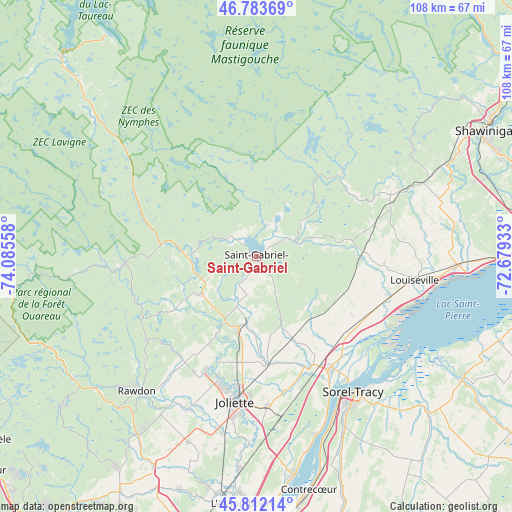
Saint-Gabriel GPS coordinates[2]
46° 18' 0.252" North, 73° 22' 56.82" West
| Map corner | latitude | longitude |
|---|---|---|
| Upper-left | 46.78369°, | -74.08558° |
| Center: | 46.30007°, | -73.38245° |
| Lower-right: | 45.81214°, | -72.67933° |
| Map W x H: | 108×108 km | = 67.1×67.1mi |
| max Lat: | 73.03752° ⇑57.5% North |
| Saint-Gabriel: | 46.30007° |
| min Lat: | ⇓42.5% South 42.05009° |
| min Long | Saint-Gabriel | max Long |
| -139.43328° | -73.38245° | -52.70931° |
| W 69.5%⇐ | ⇒30.5% E |
Elevation
Elevation of Saint-Gabriel is 190 m = 623 ft, and this is 64.4 m = 211 ft below average elevation for this country.
| Max E: |
1518 m = 4980 ft | 46.4% |
| Avg. | 254.4 m = 835 ft | |
| Saint-Gabriel | 190 m = 623 ft | |
Min E: |
-2 m = -7 ft | 53.6% |
See also: Canada elevation on elevation.city.
Geographical zone
Saint-Gabriel is located in North temperate zone (between Tropic of Cancer and the Arctic Circle). Distance of this North polar circle is 2253.1 km =1400 mi to North.| Distance of | km | miles | from Saint-Gabriel |
|---|---|---|---|
| North Pole | 4859 | 3019.2 | to North |
| Arctic Circle | 2253.1 | 1400 | to North |
| Tropic Cancer | 2542.2 | 1579.6 | to South |
| Equator | 5148.1 | 3198.9 | to South |


Nearby cities:
15 places around Saint-Gabriel: (largest is in red/bold)
• Berthierville
28.6 km =17.8 mi,  147°
147°
• Crabtree
37.6 km =23.4 mi,  189°
189°
• Joliette
31.7 km =19.7 mi, 185°
• Louiseville
34.2 km =21.3 mi,  98°
98°
• Mandeville
7.8 km =4.8 mi,  19°
19°
• Maskinongé
29 km =18 mi,  105°
105°
• Notre-Dame-des-Prairies
28.1 km =17.5 mi, 187°
• Rawdon
37.8 km =23.5 mi,  222°
222°
• Saint-Ambroise
28.2 km =17.5 mi,  208°
208°
• Saint-Félix-de-Valois
14.9 km =9.3 mi, 192°
• Saint-Norbert
15.4 km =9.6 mi,  160°
160°
• Saint-Thomas
31.6 km =19.6 mi,  175°
175°
• Sainte-Béatrix
21.1 km =13.1 mi,  238°
238°
• Sainte-Élisabeth
22.9 km =14.2 mi,  174°
174°
• Sorel-Tracy
35.4 km =22 mi,  144°
144°
Sources, notices
• [Note1] Compared only with cities in Canada existing in our database
• [Src1] Map data: © OpenStreetMap contributors (CC-BY-SA)
• [Src2] Other city data from geonames.org with taken over terms of usage.
• [Src3] Geographical zone / Annual Mean Temperature by Robert A. Rohde @ Wikipedia
