Buckingham geodata
Buckingham (Quebec) is a populated place; located in Canada in America/Toronto (GMT-4) time zone. With population of 16,685 people, there are 220 cities with bigger population in this country. Compared to other cities in Canada, 72.3% of cities are located further ↑North; 56.9% of cities are located further ←West and 56.7% of cities have higher elevation than Buckingham. Note1


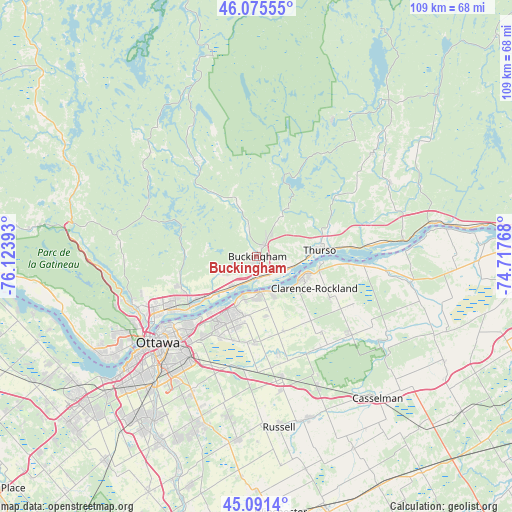
Buckingham GPS coordinates[2]
45° 35' 8.268" North, 75° 25' 14.88" West
| Map corner | latitude | longitude |
|---|---|---|
| Upper-left | 46.07555°, | -76.12393° |
| Center: | 45.58563°, | -75.4208° |
| Lower-right: | 45.0914°, | -74.71768° |
| Map W x H: | 109.4×109.4 km | = 68×68mi |
| max Lat: | 73.03752° ⇑72.3% North |
| Buckingham: | 45.58563° |
| min Lat: | ⇓27.7% South 42.05009° |
| min Long | Buckingham | max Long |
| -139.43328° | -75.4208° | -52.70931° |
| W 56.9%⇐ | ⇒43.1% E |
Elevation
Elevation of Buckingham is 124 m = 407 ft, and this is 130.4 m = 428 ft below average elevation for this country.
| Max E: |
1518 m = 4980 ft | 56.7% |
| Avg. | 254.4 m = 835 ft | |
| Buckingham | 124 m = 407 ft | |
Min E: |
-2 m = -7 ft | 43.3% |
See also: Canada elevation on elevation.city.
Geographical zone
Buckingham is located in North temperate zone (between Tropic of Cancer and the Arctic Circle). Distance of this North polar circle is 2332.5 km =1449.3 mi to North.| Distance of | km | miles | from Buckingham |
|---|---|---|---|
| North Pole | 4938.4 | 3068.6 | to North |
| Arctic Circle | 2332.5 | 1449.3 | to North |
| Tropic Cancer | 2462.7 | 1530.3 | to South |
| Equator | 5068.6 | 3149.5 | to South |


Nearby cities:
15 places around Buckingham: (largest is in red/bold)
• Bourget
27.1 km =16.8 mi,  128°
128°
• Cantley
28.2 km =17.5 mi,  265°
265°
• Clarence-Rockland
10.8 km =6.7 mi,  111°
111°
• Fallingbrook
13.2 km =8.2 mi,  201°
201°
• Gatineau
25 km =15.5 mi,  241°
241°
• Limoges
31.1 km =19.3 mi,  154°
154°
• Ottawa
29 km =18 mi,  228°
228°
• Papineauville
31.7 km =19.7 mi,  83°
83°
• Queenswood Heights
14.4 km =8.9 mi,  207°
207°
• Saint-Alexandre
27.3 km =17 mi,  249°
249°
• Saint-André-Avellin
31.2 km =19.4 mi,  62°
62°
• Thurso
13.4 km =8.3 mi, 83°
• Val-des-Monts
20.4 km =12.7 mi,  290°
290°
• Vanier
25 km =15.5 mi, 229°
• Wendover
22.9 km =14.2 mi,  93°
93°
Sources, notices
• [Note1] Compared only with cities in Canada existing in our database
• [Src1] Map data: © OpenStreetMap contributors (CC-BY-SA)
• [Src2] Other city data from geonames.org with taken over terms of usage.
• [Src3] Geographical zone / Annual Mean Temperature by Robert A. Rohde @ Wikipedia
