Clarence-Rockland geodata
Clarence-Rockland (Ontario) is a populated place; located in Canada in America/Toronto (GMT-4) time zone. With population of 20,790 people, there are 182 cities with bigger population in this country. Compared to other cities in Canada, 73.3% of cities are located further ↑North; 57.2% of cities are located further ←West and 69.9% of cities have higher elevation than Clarence-Rockland. Note1


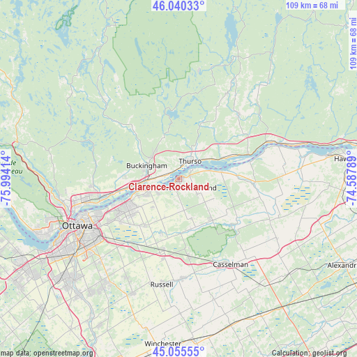
Clarence-Rockland GPS coordinates[2]
45° 33' 0.36" North, 75° 17' 27.636" West
| Map corner | latitude | longitude |
|---|---|---|
| Upper-left | 46.04033°, | -75.99414° |
| Center: | 45.5501°, | -75.29101° |
| Lower-right: | 45.05555°, | -74.58789° |
| Map W x H: | 109.5×109.5 km | = 68×68mi |
| max Lat: | 73.03752° ⇑73.3% North |
| Clarence-Rockland: | 45.5501° |
| min Lat: | ⇓26.7% South 42.05009° |
| min Long | Clarence-Rockla | max Long |
| -139.43328° | -75.29101° | -52.70931° |
| W 57.2%⇐ | ⇒42.8% E |
Elevation
Elevation of Clarence-Rockland is 55 m = 180 ft, and this is 199.4 m = 654 ft below average elevation for this country.
| Max E: |
1518 m = 4980 ft | 69.9% |
| Avg. | 254.4 m = 835 ft | |
| Clarence-Rockland | 55 m = 180 ft | |
Min E: |
-2 m = -7 ft | 30.1% |
See also: Canada elevation on elevation.city.
Geographical zone
Clarence-Rockland is located in North temperate zone (between Tropic of Cancer and the Arctic Circle). Distance of this North polar circle is 2336.5 km =1451.8 mi to North.| Distance of | km | miles | from Clarence-Rockland |
|---|---|---|---|
| North Pole | 4942.4 | 3071.1 | to North |
| Arctic Circle | 2336.5 | 1451.8 | to North |
| Tropic Cancer | 2458.8 | 1527.8 | to South |
| Equator | 5064.7 | 3147.1 | to South |


Nearby cities:
15 places around Clarence-Rockland: (largest is in red/bold)
• Bourget
17 km =10.6 mi,  139°
139°
• Buckingham
10.8 km =6.7 mi,  291°
291°
• Casselman
30.6 km =19 mi,  147°
147°
• Fallingbrook
17.2 km =10.7 mi,  241°
241°
• Gatineau
33 km =20.5 mi,  255°
255°
• Limoges
24.3 km =15.1 mi,  172°
172°
• Montebello
30 km =18.6 mi,  68°
68°
• Papineauville
22.7 km =14.1 mi, 70°
• Plantagenet
23.2 km =14.4 mi,  94°
94°
• Queenswood Heights
18.9 km =11.7 mi, 242°
• Saint-André-Avellin
25.5 km =15.8 mi,  43°
43°
• Thurso
6.4 km =4 mi,  30°
30°
• Val-des-Monts
31.2 km =19.4 mi, 290°
• Vanier
31.6 km =19.6 mi,  247°
247°
• Wendover
13 km =8.1 mi,  78°
78°
Sources, notices
• [Note1] Compared only with cities in Canada existing in our database
• [Src1] Map data: © OpenStreetMap contributors (CC-BY-SA)
• [Src2] Other city data from geonames.org with taken over terms of usage.
• [Src3] Geographical zone / Annual Mean Temperature by Robert A. Rohde @ Wikipedia
