Queenswood Heights geodata
Queenswood Heights (Ontario) is a populated place; located in Canada in America/Toronto (GMT-4) time zone. With population of 12,000 people, there are 277 cities with bigger population in this country. Compared to other cities in Canada, 75.6% of cities are located further ↑North; 56.5% of cities are located further ←West and 63% of cities have higher elevation than Queenswood Heights. Note1


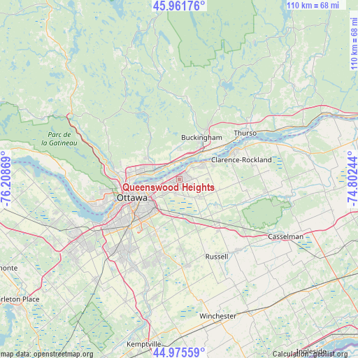
Queenswood Heights GPS coordinates[2]
45° 28' 14.988" North, 75° 30' 20.016" West
| Map corner | latitude | longitude |
|---|---|---|
| Upper-left | 45.96176°, | -76.20869° |
| Center: | 45.47083°, | -75.50556° |
| Lower-right: | 44.97559°, | -74.80244° |
| Map W x H: | 109.7×109.6 km | = 68.2×68.1mi |
| max Lat: | 73.03752° ⇑75.6% North |
| Queenswood Heights: | 45.47083° |
| min Lat: | ⇓24.4% South 42.05009° |
| min Long | Queenswood Heig | max Long |
| -139.43328° | -75.50556° | -52.70931° |
| W 56.5%⇐ | ⇒43.5% E |
Elevation
Elevation of Queenswood Heights is 86 m = 282 ft, and this is 168.4 m = 552 ft below average elevation for this country.
| Max E: |
1518 m = 4980 ft | 63% |
| Avg. | 254.4 m = 835 ft | |
| Queenswood Heights | 86 m = 282 ft | |
Min E: |
-2 m = -7 ft | 37% |
See also: Canada elevation on elevation.city.
Geographical zone
Queenswood Heights is located in North temperate zone (between Tropic of Cancer and the Arctic Circle). Distance of this North polar circle is 2345.3 km =1457.3 mi to North.| Distance of | km | miles | from Queenswood Heights |
|---|---|---|---|
| North Pole | 4951.2 | 3076.5 | to North |
| Arctic Circle | 2345.3 | 1457.3 | to North |
| Tropic Cancer | 2450 | 1522.4 | to South |
| Equator | 5055.9 | 3141.6 | to South |


Nearby cities:
15 places around Queenswood Heights: (largest is in red/bold)
• Buckingham
14.4 km =8.9 mi,  27°
27°
• Cantley
24.1 km =15 mi,  296°
296°
• Clarence-Rockland
18.9 km =11.7 mi,  62°
62°
• Fallingbrook
1.8 km =1.1 mi,  72°
72°
• Gatineau
15.3 km =9.5 mi,  272°
272°
• Limoges
25.2 km =15.7 mi,  127°
127°
• Metcalfe
26.6 km =16.5 mi,  173°
173°
• Nepean
22.5 km =14 mi,  234°
234°
• Ottawa
16.4 km =10.2 mi,  246°
246°
• Russell
26.9 km =16.7 mi,  156°
156°
• Saint-Alexandre
19.3 km =12 mi,  279°
279°
• Thurso
24.6 km =15.3 mi,  54°
54°
• Val-des-Monts
23.5 km =14.6 mi,  327°
327°
• Vanier
12.9 km =8 mi, 254°
• le Plateau
21.8 km =13.5 mi,  259°
259°
Sources, notices
• [Note1] Compared only with cities in Canada existing in our database
• [Src1] Map data: © OpenStreetMap contributors (CC-BY-SA)
• [Src2] Other city data from geonames.org with taken over terms of usage.
• [Src3] Geographical zone / Annual Mean Temperature by Robert A. Rohde @ Wikipedia
