Limoges geodata
Limoges (Ontario) is a populated place; located in Canada in America/Toronto (GMT-4) time zone. With population of 2,048 people, there are 744 cities with bigger population in this country. Compared to other cities in Canada, 80% of cities are located further ↑North; 57.2% of cities are located further ←West and 66.8% of cities have higher elevation than Limoges. Note1


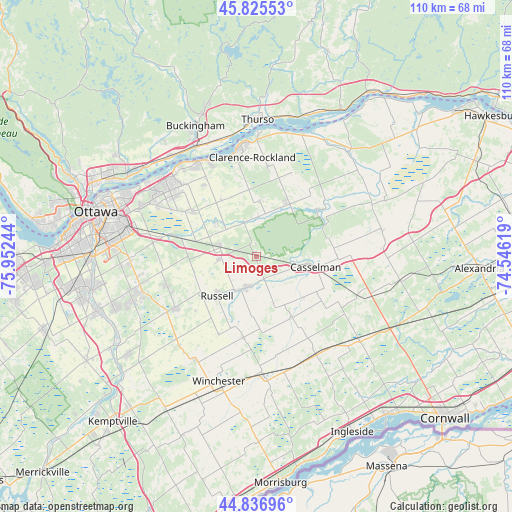
Limoges GPS coordinates[2]
45° 20' 0.24" North, 75° 14' 57.516" West
| Map corner | latitude | longitude |
|---|---|---|
| Upper-left | 45.82553°, | -75.95244° |
| Center: | 45.3334°, | -75.24931° |
| Lower-right: | 44.83696°, | -74.54619° |
| Map W x H: | 109.9×109.9 km | = 68.3×68.3mi |
| max Lat: | 73.03752° ⇑80% North |
| Limoges: | 45.3334° |
| min Lat: | ⇓20% South 42.05009° |
| min Long | Limoges | max Long |
| -139.43328° | -75.24931° | -52.70931° |
| W 57.2%⇐ | ⇒42.8% E |
Elevation
Elevation of Limoges is 68 m = 223 ft, and this is 186.4 m = 612 ft below average elevation for this country.
| Max E: |
1518 m = 4980 ft | 66.8% |
| Avg. | 254.4 m = 835 ft | |
| Limoges | 68 m = 223 ft | |
Min E: |
-2 m = -7 ft | 33.2% |
See also: Canada elevation on elevation.city.
Geographical zone
Limoges is located in North temperate zone (between Tropic of Cancer and the Arctic Circle). Distance of this North polar circle is 2360.6 km =1466.8 mi to North.| Distance of | km | miles | from Limoges |
|---|---|---|---|
| North Pole | 4966.5 | 3086 | to North |
| Arctic Circle | 2360.6 | 1466.8 | to North |
| Tropic Cancer | 2434.7 | 1512.9 | to South |
| Equator | 5040.6 | 3132.1 | to South |


Nearby cities:
15 places around Limoges: (largest is in red/bold)
• Bourget
13.6 km =8.5 mi,  35°
35°
• Buckingham
31.1 km =19.3 mi,  334°
334°
• Casselman
13.2 km =8.2 mi,  98°
98°
• Clarence-Rockland
24.3 km =15.1 mi,  352°
352°
• Fallingbrook
24.2 km =15 mi,  310°
310°
• Metcalfe
20.3 km =12.6 mi,  236°
236°
• Osgoode
34.1 km =21.2 mi,  233°
233°
• Ottawa
36.1 km =22.4 mi,  283°
283°
• Plantagenet
29.8 km =18.5 mi, 42°
• Queenswood Heights
25.2 km =15.7 mi, 307°
• Russell
13 km =8.1 mi,  224°
224°
• Thurso
29.7 km =18.5 mi,  0°
0°
• Vanier
34.6 km =21.5 mi,  290°
290°
• Wendover
28.3 km =17.6 mi,  19°
19°
• Winchester
28.9 km =18 mi,  195°
195°
Sources, notices
• [Note1] Compared only with cities in Canada existing in our database
• [Src1] Map data: © OpenStreetMap contributors (CC-BY-SA)
• [Src2] Other city data from geonames.org with taken over terms of usage.
• [Src3] Geographical zone / Annual Mean Temperature by Robert A. Rohde @ Wikipedia
