Amqui geodata
Amqui (Quebec) is a populated place; located in Canada in America/Toronto (GMT-4) time zone. With population of 6,261 people, there are 423 cities with bigger population in this country. Compared to other cities in Canada, 57.5% of cities are located further ↓South; 85.7% of cities are located further ←West and 51.6% of cities have higher elevation than Amqui. Note1


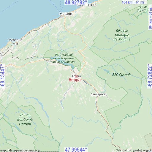
Amqui GPS coordinates[2]
48° 27' 49.752" North, 67° 25' 52.824" West
| Map corner | latitude | longitude |
|---|---|---|
| Upper-left | 48.92792°, | -68.13447° |
| Center: | 48.46382°, | -67.43134° |
| Lower-right: | 47.99544°, | -66.72822° |
| Map W x H: | 103.7×103.7 km | = 64.4×64.4mi |
| max Lat: | 73.03752° ⇑42.5% North |
| Amqui: | 48.46382° |
| min Lat: | ⇓57.5% South 42.05009° |
| min Long | Amqui | max Long |
| -139.43328° | -67.43134° | -52.70931° |
| W 85.7%⇐ | ⇒14.3% E |
Elevation
Elevation of Amqui is 161 m = 528 ft, and this is 93.4 m = 306 ft below average elevation for this country.
| Max E: |
1518 m = 4980 ft | 51.6% |
| Avg. | 254.4 m = 835 ft | |
| Amqui | 161 m = 528 ft | |
Min E: |
-2 m = -7 ft | 48.4% |
See also: Canada elevation on elevation.city.
Geographical zone
Amqui is located in North temperate zone (between Tropic of Cancer and the Arctic Circle). Distance of this North polar circle is 2012.5 km =1250.5 mi to North.| Distance of | km | miles | from Amqui |
|---|---|---|---|
| North Pole | 4618.4 | 2869.7 | to North |
| Arctic Circle | 2012.5 | 1250.5 | to North |
| Tropic Cancer | 2782.8 | 1729.2 | to South |
| Equator | 5388.7 | 3348.4 | to South |


Nearby cities:
15 places around Amqui: (largest is in red/bold)
• Baie-Comeau
98.8 km =61.4 mi,  327°
327°
• Campbellton
75.7 km =47 mi,  132°
132°
• Cap-Chat
89.5 km =55.6 mi,  37°
37°
• Carleton
106.5 km =66.2 mi,  112°
112°
• Carleton-sur-Mer
104.3 km =64.8 mi, 112°
• Chute-aux-Outardes
101.5 km =63.1 mi,  315°
315°
• Hauterive
101.4 km =63 mi, 323°
• Lac-des-Aigles
106.3 km =66.1 mi,  240°
240°
• Le Bic
93.7 km =58.2 mi,  263°
263°
• Luceville
71.7 km =44.6 mi,  277°
277°
• Maria
111.6 km =69.3 mi, 106°
• Matane
41.1 km =25.5 mi,  350°
350°
• Mont-Joli
57.6 km =35.8 mi, 283°
• Rimouski
80.6 km =50.1 mi,  268°
268°
• Sainte-Anne-des-Monts
100.6 km =62.5 mi, 43°
Sources, notices
• [Note1] Compared only with cities in Canada existing in our database
• [Src1] Map data: © OpenStreetMap contributors (CC-BY-SA)
• [Src2] Other city data from geonames.org with taken over terms of usage.
• [Src3] Geographical zone / Annual Mean Temperature by Robert A. Rohde @ Wikipedia
