Watsa geodata
Watsa (Haut-Uele) is a populated place; located in Democratic Republic of the Congo in Africa/Lubumbashi (GMT+2) time zone. With population of 24,516 people, there are 62 cities with bigger population in this country. Compared to other cities in Democratic Republic of the Congo, 91.4% of cities are located further ↓South; 98.6% of cities are located further ←West and 81.4% of cities have lower elevation than Watsa. Note1


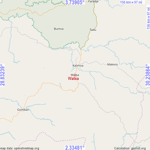
Watsa GPS coordinates[2]
3° 2' 13.776" North, 29° 32' 7.836" East
| Map corner | latitude | longitude |
|---|---|---|
| Upper-left | 3.73905°, | 28.83239° |
| Center: | 3.03716°, | 29.53551° |
| Lower-right: | 2.33481°, | 30.23864° |
| Map W x H: | 156.1×156.1 km | = 97×97mi |
| max Lat: | 4.279° ⇑8.6% North |
| Watsa: | 3.03716° |
| min Lat: | ⇓91.4% South -11.76097° |
| min Long | Watsa | max Long |
| 12.37148° | 29.53551° | 30.25224° |
| W 98.6%⇐ | ⇒1.4% E |
Elevation
Elevation of Watsa is 1018 m = 3340 ft, and this is 362 m = 1188 ft above average elevation for this country.
| Max E: |
1996 m = 6549 ft | 18.6% |
| Watsa | 1018 m 3340 ft | |
| Avg. | 656 m = 2152 ft | |
Min E: |
11 m = 36 ft | 81.4% |
See also: Democratic Republic of the Congo elevation on elevation.city.
Geographical zone
Watsa is located in North Torrid zone (between Equator and Tropic of Cancer). Distance of Equator is 337.7 km =209.8 mi to South.| Distance of | km | miles | from Watsa |
|---|---|---|---|
| North Pole | 9669.4 | 6008.3 | to North |
| Arctic Circle | 7063.5 | 4389.1 | to North |
| Tropic Cancer | 2268.2 | 1409.4 | to North |
| Equator | 337.7 | 209.8 | to South |


Nearby cities:
5 places around Watsa: (largest is in red/bold)
• Beni
283.2 km =176 mi,  181°
181°
• Bunia
182.6 km =113.5 mi,  154°
154°
• Butembo
323.1 km =200.8 mi, 184°
• Isiro
215.2 km =133.7 mi,  262°
262°
• Wamba
197.6 km =122.8 mi,  239°
239°
Sources, notices
• [Note1] Compared only with cities in Democratic Republic of the Congo existing in our database
• [Src1] Map data: © OpenStreetMap contributors (CC-BY-SA)
• [Src2] Other city data from geonames.org with taken over terms of usage.
• [Src3] Geographical zone / Annual Mean Temperature by Robert A. Rohde @ Wikipedia
