Bunia geodata
Bunia (Ituri) is a seat of a first-order administrative division; located in Democratic Republic of the Congo in Africa/Lubumbashi (GMT+2) time zone. With population of 96,764 people, there are 26 cities with bigger population in this country. Compared to other cities in Democratic Republic of the Congo, 81.4% of cities are located further ↓South; 100% of cities are located further ←West and 87.1% of cities have lower elevation than Bunia. Note1


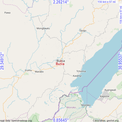
Bunia GPS coordinates[2]
1° 33' 33.876" North, 30° 15' 8.064" East
| Map corner | latitude | longitude |
|---|---|---|
| Upper-left | 2.26214°, | 29.54912° |
| Center: | 1.55941°, | 30.25224° |
| Lower-right: | 0.85645°, | 30.95537° |
| Map W x H: | 156.3×156.3 km | = 97.1×97.1mi |
| max Lat: | 4.279° ⇑18.6% North |
| Bunia: | 1.55941° |
| min Lat: | ⇓81.4% South -11.76097° |
| min Long | Bunia | max Long |
| 12.37148° | 30.25224° | 30.25224° |
| W 100%⇐ | ⇒0% E |
Elevation
Elevation of Bunia is 1265 m = 4150 ft, and this is 609 m = 1998 ft above average elevation for this country.
| Max E: |
1996 m = 6549 ft | 12.9% |
| Bunia | 1265 m 4150 ft | |
| Avg. | 656 m = 2152 ft | |
Min E: |
11 m = 36 ft | 87.1% |
See also: Bunia elevation on elevation.city.
Geographical zone
Bunia is located in North Torrid zone (between Equator and Tropic of Cancer). Distance of Equator is 173.4 km =107.7 mi to South.| Distance of | km | miles | from Bunia |
|---|---|---|---|
| North Pole | 9833.7 | 6110.4 | to North |
| Arctic Circle | 7227.8 | 4491.1 | to North |
| Tropic Cancer | 2432.5 | 1511.5 | to North |
| Equator | 173.4 | 107.7 | to South |


Nearby cities:
7 places around Bunia: (largest is in red/bold)
• Beni
147 km =91.3 mi,  216°
216°
• Butembo
190.4 km =118.3 mi,  214°
214°
• Goma
377.1 km =234.3 mi,  197°
197°
• Isiro
322.5 km =200.4 mi,  294°
294°
• Sake
373.4 km =232 mi, 201°
• Wamba
259.3 km =161.1 mi,  284°
284°
• Watsa
182.6 km =113.5 mi,  334°
334°
Sources, notices
• [Note1] Compared only with cities in Democratic Republic of the Congo existing in our database
• [Src1] Map data: © OpenStreetMap contributors (CC-BY-SA)
• [Src2] Other city data from geonames.org with taken over terms of usage.
• [Src3] Geographical zone / Annual Mean Temperature by Robert A. Rohde @ Wikipedia
