Beni geodata
Beni (Nord Kivu) is a populated place; located in Democratic Republic of the Congo in Africa/Lubumbashi (GMT+2) time zone. With population of 232,000 people, there are 9 cities with bigger population in this country. Compared to other cities in Democratic Republic of the Congo, 74.3% of cities are located further ↓South; 97.1% of cities are located further ←West and 84.3% of cities have lower elevation than Beni. Note1


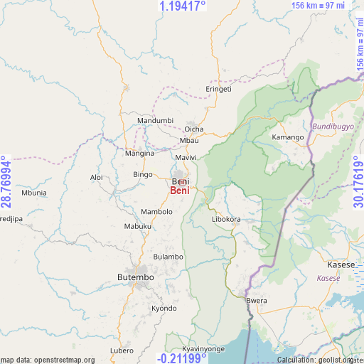
Beni GPS coordinates[2]
0° 29' 28.068" North, 29° 28' 23.016" East
| Map corner | latitude | longitude |
|---|---|---|
| Upper-left | 1.19417°, | 28.76994° |
| Center: | 0.49113°, | 29.47306° |
| Lower-right: | -0.21199°, | 30.17619° |
| Map W x H: | 156.4×156.4 km | = 97.2×97.2mi |
| max Lat: | 4.279° ⇑25.7% North |
| Beni: | 0.49113° |
| min Lat: | ⇓74.3% South -11.76097° |
| min Long | Beni | max Long |
| 12.37148° | 29.47306° | 30.25224° |
| W 97.1%⇐ | ⇒2.9% E |
Elevation
Elevation of Beni is 1161 m = 3809 ft, and this is 505 m = 1657 ft above average elevation for this country.
| Max E: |
1996 m = 6549 ft | 15.7% |
| Beni | 1161 m 3809 ft | |
| Avg. | 656 m = 2152 ft | |
Min E: |
11 m = 36 ft | 84.3% |
See also: Beni elevation on elevation.city.
Geographical zone
Beni is located in North Torrid zone (between Equator and Tropic of Cancer). Distance of Equator is 54.6 km =33.9 mi to South.| Distance of | km | miles | from Beni |
|---|---|---|---|
| North Pole | 9952.5 | 6184.2 | to North |
| Arctic Circle | 7346.6 | 4565 | to North |
| Tropic Cancer | 2551.3 | 1585.3 | to North |
| Equator | 54.6 | 33.9 | to South |


Nearby cities:
10 places around Beni: (largest is in red/bold)
• Bukavu
338.9 km =210.6 mi,  191°
191°
• Bunia
147 km =91.3 mi,  36°
36°
• Butembo
43.8 km =27.2 mi,  207°
207°
• Goma
242.3 km =150.6 mi, 186°
• Isiro
327.1 km =203.3 mi,  320°
320°
• Kabare
340.8 km =211.8 mi, 192°
• Sake
234.5 km =145.7 mi, 191°
• Uvira
433.7 km =269.5 mi,  184°
184°
• Wamba
246.9 km =153.4 mi, 318°
• Watsa
283.2 km =176 mi,  1°
1°
Sources, notices
• [Note1] Compared only with cities in Democratic Republic of the Congo existing in our database
• [Src1] Map data: © OpenStreetMap contributors (CC-BY-SA)
• [Src2] Other city data from geonames.org with taken over terms of usage.
• [Src3] Geographical zone / Annual Mean Temperature by Robert A. Rohde @ Wikipedia
