Butembo geodata
Butembo (Nord Kivu) is a seat of a third-order administrative division; located in Democratic Republic of the Congo in Africa/Lubumbashi (GMT+2) time zone. With population of 154,621 people, there are 17 cities with bigger population in this country. Compared to other cities in Democratic Republic of the Congo, 72.9% of cities are located further ↓South; 95.7% of cities are located further ←West and 98.6% of cities have lower elevation than Butembo. Note1


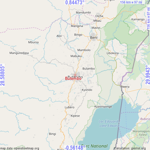
Butembo GPS coordinates[2]
0° 8' 29.904" North, 29° 17' 28.212" East
| Map corner | latitude | longitude |
|---|---|---|
| Upper-left | 0.84473°, | 28.58805° |
| Center: | 0.14164°, | 29.29117° |
| Lower-right: | -0.56148°, | 29.9943° |
| Map W x H: | 156.4×156.4 km | = 97.2×97.2mi |
| max Lat: | 4.279° ⇑27.1% North |
| Butembo: | 0.14164° |
| min Lat: | ⇓72.9% South -11.76097° |
| min Long | Butembo | max Long |
| 12.37148° | 29.29117° | 30.25224° |
| W 95.7%⇐ | ⇒4.3% E |
Elevation
Elevation of Butembo is 1736 m = 5696 ft, and this is 1080 m = 3543 ft above average elevation for this country.
| Max E: |
1996 m = 6549 ft | 1.4% |
| Butembo | 1736 m 5696 ft | |
| Avg. | 656 m = 2152 ft | |
Min E: |
11 m = 36 ft | 98.6% |
See also: Butembo elevation on elevation.city.
Geographical zone
Butembo is located in North Torrid zone (between Equator and Tropic of Cancer). Distance of Equator is 15.7 km =9.8 mi to South.| Distance of | km | miles | from Butembo |
|---|---|---|---|
| North Pole | 9991.3 | 6208.3 | to North |
| Arctic Circle | 7385.4 | 4589.1 | to North |
| Tropic Cancer | 2590.2 | 1609.5 | to North |
| Equator | 15.7 | 9.8 | to South |


Nearby cities:
10 places around Butembo: (largest is in red/bold)
• Beni
43.8 km =27.2 mi,  27°
27°
• Bukavu
296.9 km =184.5 mi,  189°
189°
• Bunia
190.4 km =118.3 mi, 34°
• Goma
202 km =125.5 mi,  181°
181°
• Isiro
346.9 km =215.6 mi,  327°
327°
• Kabare
298.6 km =185.5 mi, 190°
• Sake
192.7 km =119.7 mi, 188°
• Uvira
393.6 km =244.6 mi, 182°
• Wamba
265.6 km =165 mi, 327°
• Watsa
323.1 km =200.8 mi,  4°
4°
Sources, notices
• [Note1] Compared only with cities in Democratic Republic of the Congo existing in our database
• [Src1] Map data: © OpenStreetMap contributors (CC-BY-SA)
• [Src2] Other city data from geonames.org with taken over terms of usage.
• [Src3] Geographical zone / Annual Mean Temperature by Robert A. Rohde @ Wikipedia
