Zuzgen geodata
Zuzgen (Aargau) is a populated place; located in Switzerland in Europe/Zurich (GMT+2) time zone. With population of 863 people, there are 1444 cities with bigger population in this country. Compared to other cities in Switzerland, 92.7% of cities are located further ↓South; 62.5% of cities are located further →East and 94% of cities have higher elevation than Zuzgen. Note1


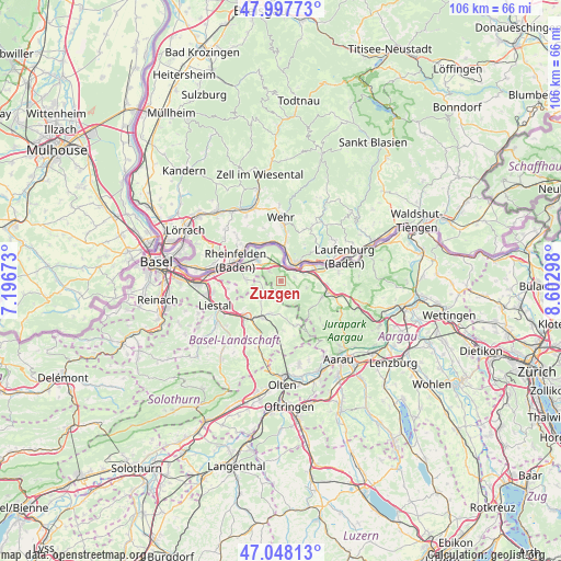
Zuzgen GPS coordinates[2]
47° 31' 30.288" North, 7° 53' 59.496" East
| Map corner | latitude | longitude |
|---|---|---|
| Upper-left | 47.99773°, | 7.19673° |
| Center: | 47.52508°, | 7.89986° |
| Lower-right: | 47.04813°, | 8.60298° |
| Map W x H: | 105.6×105.6 km | = 65.6×65.6mi |
| max Lat: | 47.76737° ⇑7.3% North |
| Zuzgen: | 47.52508° |
| min Lat: | ⇓92.7% South 45.83203° |
| min Long | Zuzgen | max Long |
| 5.97153° | 7.89986° | 10.44624° |
| W 37.5%⇐ | ⇒62.5% E |
Elevation
Elevation of Zuzgen is 373 m = 1224 ft, and this is 185.2 m = 608 ft below average elevation for this country.
| Max E: |
1845 m = 6053 ft | 94% |
| Avg. | 558.2 m = 1831 ft | |
| Zuzgen | 373 m = 1224 ft | |
Min E: |
197 m = 646 ft | 6% |
See also: Switzerland elevation on elevation.city.
Geographical zone
Zuzgen is located in North temperate zone (between Tropic of Cancer and the Arctic Circle). Distance of this North polar circle is 2116.9 km =1315.4 mi to North.| Distance of | km | miles | from Zuzgen |
|---|---|---|---|
| North Pole | 4722.8 | 2934.6 | to North |
| Arctic Circle | 2116.9 | 1315.4 | to North |
| Tropic Cancer | 2678.4 | 1664.3 | to South |
| Equator | 5284.3 | 3283.5 | to South |


Nearby cities:
15 places around Zuzgen: (largest is in red/bold)
• Buus
3.4 km =2.1 mi,  232°
232°
• Eiken
6.7 km =4.2 mi,  81°
81°
• Frick
9.5 km =5.9 mi,  99°
99°
• Gelterkinden
7.6 km =4.7 mi,  208°
208°
• Gipf-Oberfrick
8.4 km =5.2 mi,  110°
110°
• Magden
6.7 km =4.2 mi,  273°
273°
• Maisprach
4.1 km =2.5 mi, 269°
• Mumpf
2.8 km =1.7 mi,  35°
35°
• Möhlin
5.7 km =3.5 mi,  311°
311°
• Ormalingen
6.5 km =4 mi,  198°
198°
• Rheinfelden
8.6 km =5.3 mi,  292°
292°
• Stein
4.5 km =2.8 mi,  61°
61°
• Tecknau
8.5 km =5.3 mi,  187°
187°
• Wegenstetten
3.8 km =2.4 mi,  141°
141°
• Wittnau
7.5 km =4.7 mi,  130°
130°
Sources, notices
• [Note1] Compared only with cities in Switzerland existing in our database
• [Src1] Map data: © OpenStreetMap contributors (CC-BY-SA)
• [Src2] Other city data from geonames.org with taken over terms of usage.
• [Src3] Geographical zone / Annual Mean Temperature by Robert A. Rohde @ Wikipedia
