Tecknau geodata
Tecknau (Basel-Landschaft) is a populated place; located in Switzerland in Europe/Zurich (GMT+2) time zone. With population of 856 people, there are 1450 cities with bigger population in this country. Compared to other cities in Switzerland, 82.2% of cities are located further ↓South; 62.9% of cities are located further →East and 69.1% of cities have higher elevation than Tecknau. Note1


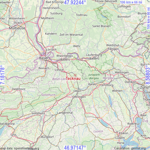
Tecknau GPS coordinates[2]
47° 26' 56.76" North, 7° 53' 5.676" East
| Map corner | latitude | longitude |
|---|---|---|
| Upper-left | 47.92244°, | 7.18178° |
| Center: | 47.4491°, | 7.88491° |
| Lower-right: | 46.97147°, | 8.58803° |
| Map W x H: | 105.7×105.7 km | = 65.7×65.7mi |
| max Lat: | 47.76737° ⇑17.8% North |
| Tecknau: | 47.4491° |
| min Lat: | ⇓82.2% South 45.83203° |
| min Long | Tecknau | max Long |
| 5.97153° | 7.88491° | 10.44624° |
| W 37.1%⇐ | ⇒62.9% E |
Elevation
Elevation of Tecknau is 440 m = 1444 ft, and this is 118.2 m = 388 ft below average elevation for this country.
| Max E: |
1845 m = 6053 ft | 69.1% |
| Avg. | 558.2 m = 1831 ft | |
| Tecknau | 440 m = 1444 ft | |
Min E: |
197 m = 646 ft | 30.9% |
See also: Switzerland elevation on elevation.city.
Geographical zone
Tecknau is located in North temperate zone (between Tropic of Cancer and the Arctic Circle). Distance of this North polar circle is 2125.3 km =1320.6 mi to North.| Distance of | km | miles | from Tecknau |
|---|---|---|---|
| North Pole | 4731.2 | 2939.8 | to North |
| Arctic Circle | 2125.3 | 1320.6 | to North |
| Tropic Cancer | 2669.9 | 1659 | to South |
| Equator | 5275.8 | 3278.2 | to South |


Nearby cities:
15 places around Tecknau: (largest is in red/bold)
• Buckten
5.3 km =3.3 mi,  214°
214°
• Buus
6.6 km =4.1 mi,  346°
346°
• Diegten
6.8 km =4.2 mi,  234°
234°
• Gelterkinden
3.1 km =1.9 mi,  305°
305°
• Känerkinden
5.5 km =3.4 mi,  220°
220°
• Läufelfingen
6.4 km =4 mi,  199°
199°
• Ormalingen
2.4 km =1.5 mi,  337°
337°
• Rohr
6.7 km =4.2 mi,  129°
129°
• Rünenberg
1.7 km =1.1 mi,  185°
185°
• Sissach
6 km =3.7 mi,  286°
286°
• Tenniken
5.7 km =3.5 mi,  256°
256°
• Wegenstetten
6.5 km =4 mi,  32°
32°
• Wittnau
7.7 km =4.8 mi,  62°
62°
• Zeglingen
3.9 km =2.4 mi,  155°
155°
• Zunzgen
5.8 km =3.6 mi,  270°
270°
Sources, notices
• [Note1] Compared only with cities in Switzerland existing in our database
• [Src1] Map data: © OpenStreetMap contributors (CC-BY-SA)
• [Src2] Other city data from geonames.org with taken over terms of usage.
• [Src3] Geographical zone / Annual Mean Temperature by Robert A. Rohde @ Wikipedia
