Rheinfelden geodata
Rheinfelden (Aargau) is a seat of a second-order administrative division; located in Switzerland in Europe/Zurich (GMT+2) time zone. With population of 10,733 people, there are 127 cities with bigger population in this country. Compared to other cities in Switzerland, 95.2% of cities are located further ↓South; 65.8% of cities are located further →East and 98.4% of cities have higher elevation than Rheinfelden. Note1


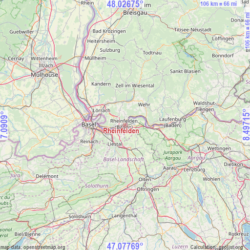
Rheinfelden GPS coordinates[2]
47° 33' 15.732" North, 7° 47' 38.508" East
| Map corner | latitude | longitude |
|---|---|---|
| Upper-left | 48.02675°, | 7.0909° |
| Center: | 47.55437°, | 7.79403° |
| Lower-right: | 47.07769°, | 8.49715° |
| Map W x H: | 105.5×105.5 km | = 65.6×65.6mi |
| max Lat: | 47.76737° ⇑4.8% North |
| Rheinfelden: | 47.55437° |
| min Lat: | ⇓95.2% South 45.83203° |
| min Long | Rheinfelden | max Long |
| 5.97153° | 7.79403° | 10.44624° |
| W 34.2%⇐ | ⇒65.8% E |
Elevation
Elevation of Rheinfelden is 277 m = 909 ft, and this is 281.2 m = 923 ft below average elevation for this country.
| Max E: |
1845 m = 6053 ft | 98.4% |
| Avg. | 558.2 m = 1831 ft | |
| Rheinfelden | 277 m = 909 ft | |
Min E: |
197 m = 646 ft | 1.6% |
See also: Switzerland elevation on elevation.city.
Geographical zone
Rheinfelden is located in North temperate zone (between Tropic of Cancer and the Arctic Circle). Distance of this North polar circle is 2113.6 km =1313.3 mi to North.| Distance of | km | miles | from Rheinfelden |
|---|---|---|---|
| North Pole | 4719.5 | 2932.6 | to North |
| Arctic Circle | 2113.6 | 1313.3 | to North |
| Tropic Cancer | 2681.6 | 1666.3 | to South |
| Equator | 5287.6 | 3285.6 | to South |


Nearby cities:
15 places around Rheinfelden: (largest is in red/bold)
• Arisdorf
5.1 km =3.2 mi,  205°
205°
• Augst
6.3 km =3.9 mi,  250°
250°
• Buus
7.5 km =4.7 mi,  135°
135°
• Frenkendorf
7.9 km =4.9 mi,  227°
227°
• Füllinsdorf
7.1 km =4.4 mi,  221°
221°
• Itingen
9.8 km =6.1 mi,  183°
183°
• Kaiseraugst
5.4 km =3.4 mi, 252°
• Lausen
9.6 km =6 mi,  195°
195°
• Liestal
9 km =5.6 mi, 209°
• Magden
3.1 km =1.9 mi,  155°
155°
• Maisprach
5.1 km =3.2 mi,  130°
130°
• Mumpf
9.6 km =6 mi,  95°
95°
• Möhlin
3.7 km =2.3 mi,  81°
81°
• Pratteln
8.4 km =5.2 mi,  243°
243°
• Zuzgen
8.6 km =5.3 mi,  112°
112°
Sources, notices
• [Note1] Compared only with cities in Switzerland existing in our database
• [Src1] Map data: © OpenStreetMap contributors (CC-BY-SA)
• [Src2] Other city data from geonames.org with taken over terms of usage.
• [Src3] Geographical zone / Annual Mean Temperature by Robert A. Rohde @ Wikipedia
