Walterswil geodata
Walterswil (Bern) is a populated place; located in Switzerland in Europe/Zurich (GMT+2) time zone. With population of 639 people, there are 1659 cities with bigger population in this country. Compared to other cities in Switzerland, 58.5% of cities are located further ↑North; 66.3% of cities are located further →East and 80.6% of cities have lower elevation than Walterswil. Note1


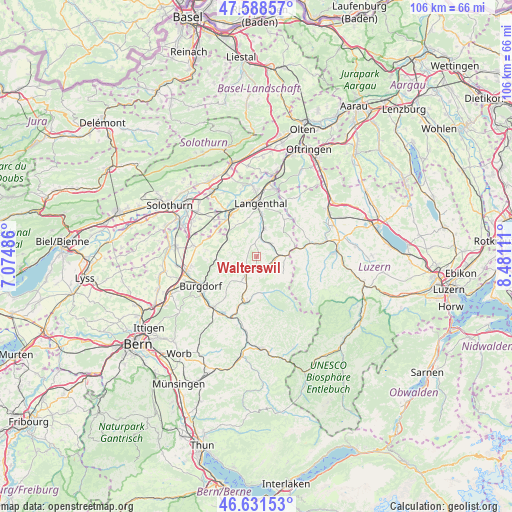
Walterswil GPS coordinates[2]
47° 6' 43.92" North, 7° 46' 40.728" East
| Map corner | latitude | longitude |
|---|---|---|
| Upper-left | 47.58857°, | 7.07486° |
| Center: | 47.1122°, | 7.77798° |
| Lower-right: | 46.63153°, | 8.48111° |
| Map W x H: | 106.4×106.4 km | = 66.1×66.1mi |
| max Lat: | 47.76737° ⇑58.5% North |
| Walterswil: | 47.1122° |
| min Lat: | ⇓41.5% South 45.83203° |
| min Long | Walterswil | max Long |
| 5.97153° | 7.77798° | 10.44624° |
| W 33.7%⇐ | ⇒66.3% E |
Elevation
Elevation of Walterswil is 667 m = 2188 ft, and this is 108.8 m = 357 ft above average elevation for this country.
| Max E: |
1845 m = 6053 ft | 19.4% |
| Walterswil | 667 m 2188 ft | |
| Avg. | 558.2 m = 1831 ft | |
Min E: |
197 m = 646 ft | 80.6% |
See also: Switzerland elevation on elevation.city.
Geographical zone
Walterswil is located in North temperate zone (between Tropic of Cancer and the Arctic Circle). Distance of this North polar circle is 2162.8 km =1343.9 mi to North.| Distance of | km | miles | from Walterswil |
|---|---|---|---|
| North Pole | 4768.7 | 2963.1 | to North |
| Arctic Circle | 2162.8 | 1343.9 | to North |
| Tropic Cancer | 2632.5 | 1635.8 | to South |
| Equator | 5238.4 | 3255 | to South |


Nearby cities:
15 places around Walterswil: (largest is in red/bold)
• Auswil
4.9 km =3 mi,  56°
56°
• Busswil bei Melchnau
9.1 km =5.7 mi,  26°
26°
• Dürrenroth
2.7 km =1.7 mi,  157°
157°
• Eriswil
6.7 km =4.2 mi,  124°
124°
• Gondiswil
8 km =5 mi, 61°
• Huttwil
6.4 km =4 mi,  87°
87°
• Kleindietwil
3.8 km =2.4 mi,  13°
13°
• Lotzwil
8.9 km =5.5 mi, 6°
• Madiswil
6 km =3.7 mi, 14°
• Ochlenberg
5.2 km =3.2 mi,  322°
322°
• Rohrbach
3.7 km =2.3 mi,  46°
46°
• Ufhusen
9 km =5.6 mi, 86°
• Ursenbach
2.8 km =1.7 mi,  350°
350°
• Wynigen
8.4 km =5.2 mi,  265°
265°
• Wyssachen
5.4 km =3.4 mi,  134°
134°
Sources, notices
• [Note1] Compared only with cities in Switzerland existing in our database
• [Src1] Map data: © OpenStreetMap contributors (CC-BY-SA)
• [Src2] Other city data from geonames.org with taken over terms of usage.
• [Src3] Geographical zone / Annual Mean Temperature by Robert A. Rohde @ Wikipedia
