Dürrenroth geodata
Dürrenroth (Bern) is a populated place; located in Switzerland in Europe/Zurich (GMT+2) time zone. With population of 1,037 people, there are 1304 cities with bigger population in this country. Compared to other cities in Switzerland, 59.4% of cities are located further ↑North; 65.8% of cities are located further →East and 82.8% of cities have lower elevation than Dürrenroth. Note1


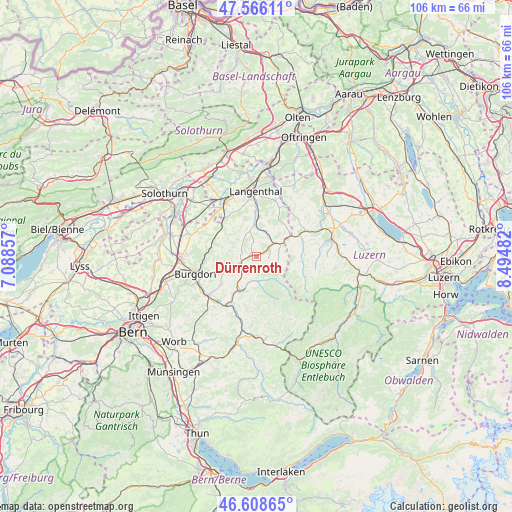
Dürrenroth GPS coordinates[2]
47° 5' 22.308" North, 7° 47' 30.12" East
| Map corner | latitude | longitude |
|---|---|---|
| Upper-left | 47.56611°, | 7.08857° |
| Center: | 47.08953°, | 7.7917° |
| Lower-right: | 46.60865°, | 8.49482° |
| Map W x H: | 106.5×106.5 km | = 66.2×66.2mi |
| max Lat: | 47.76737° ⇑59.4% North |
| Dürrenroth: | 47.08953° |
| min Lat: | ⇓40.6% South 45.83203° |
| min Long | Dürrenroth | max Long |
| 5.97153° | 7.7917° | 10.44624° |
| W 34.2%⇐ | ⇒65.8% E |
Elevation
Elevation of Dürrenroth is 704 m = 2310 ft, and this is 145.8 m = 478 ft above average elevation for this country.
| Max E: |
1845 m = 6053 ft | 17.2% |
| Dürrenroth | 704 m 2310 ft | |
| Avg. | 558.2 m = 1831 ft | |
Min E: |
197 m = 646 ft | 82.8% |
See also: Switzerland elevation on elevation.city.
Geographical zone
Dürrenroth is located in North temperate zone (between Tropic of Cancer and the Arctic Circle). Distance of this North polar circle is 2165.3 km =1345.5 mi to North.| Distance of | km | miles | from Dürrenroth |
|---|---|---|---|
| North Pole | 4771.2 | 2964.7 | to North |
| Arctic Circle | 2165.3 | 1345.5 | to North |
| Tropic Cancer | 2629.9 | 1634.1 | to South |
| Equator | 5235.9 | 3253.4 | to South |


Nearby cities:
15 places around Dürrenroth: (largest is in red/bold)
• Auswil
6 km =3.7 mi,  30°
30°
• Eriswil
4.7 km =2.9 mi,  105°
105°
• Gondiswil
8.8 km =5.5 mi,  43°
43°
• Huttwil
6 km =3.7 mi,  61°
61°
• Kleindietwil
6.2 km =3.9 mi,  358°
358°
• Madiswil
8.4 km =5.2 mi,  3°
3°
• Ochlenberg
7.9 km =4.9 mi,  327°
327°
• Rohrbach
5.3 km =3.3 mi,  17°
17°
• Sumiswald
7.7 km =4.8 mi,  207°
207°
• Trachselwald
9.1 km =5.7 mi, 207°
• Ufhusen
8.5 km =5.3 mi,  68°
68°
• Ursenbach
5.5 km =3.4 mi,  344°
344°
• Walterswil
2.7 km =1.7 mi, 337°
• Wynigen
9.6 km =6 mi,  280°
280°
• Wyssachen
3.1 km =1.9 mi, 113°
Sources, notices
• [Note1] Compared only with cities in Switzerland existing in our database
• [Src1] Map data: © OpenStreetMap contributors (CC-BY-SA)
• [Src2] Other city data from geonames.org with taken over terms of usage.
• [Src3] Geographical zone / Annual Mean Temperature by Robert A. Rohde @ Wikipedia
