Wynigen geodata
Wynigen (Bern) is a populated place; located in Switzerland in Europe/Zurich (GMT+2) time zone. With population of 2,090 people, there are 808 cities with bigger population in this country. Compared to other cities in Switzerland, 58.7% of cities are located further ↑North; 69.1% of cities are located further →East and 62.3% of cities have lower elevation than Wynigen. Note1


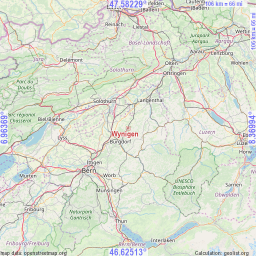
Wynigen GPS coordinates[2]
47° 6' 21.096" North, 7° 40' 0.516" East
| Map corner | latitude | longitude |
|---|---|---|
| Upper-left | 47.58229°, | 6.96369° |
| Center: | 47.10586°, | 7.66681° |
| Lower-right: | 46.62513°, | 8.36994° |
| Map W x H: | 106.4×106.4 km | = 66.1×66.1mi |
| max Lat: | 47.76737° ⇑58.7% North |
| Wynigen: | 47.10586° |
| min Lat: | ⇓41.3% South 45.83203° |
| min Long | Wynigen | max Long |
| 5.97153° | 7.66681° | 10.44624° |
| W 30.9%⇐ | ⇒69.1% E |
Elevation
Elevation of Wynigen is 532 m = 1745 ft, and this is 26.2 m = 86 ft below average elevation for this country.
| Max E: |
1845 m = 6053 ft | 37.7% |
| Avg. | 558.2 m = 1831 ft | |
| Wynigen | 532 m = 1745 ft | |
Min E: |
197 m = 646 ft | 62.3% |
See also: Switzerland elevation on elevation.city.
Geographical zone
Wynigen is located in North temperate zone (between Tropic of Cancer and the Arctic Circle). Distance of this North polar circle is 2163.5 km =1344.3 mi to North.| Distance of | km | miles | from Wynigen |
|---|---|---|---|
| North Pole | 4769.4 | 2963.6 | to North |
| Arctic Circle | 2163.5 | 1344.3 | to North |
| Tropic Cancer | 2631.8 | 1635.3 | to South |
| Equator | 5237.7 | 3254.6 | to South |


Nearby cities:
15 places around Wynigen: (largest is in red/bold)
• Alchenstorf
3.1 km =1.9 mi,  312°
312°
• Burgdorf
6 km =3.7 mi,  209°
209°
• Ersigen
5.6 km =3.5 mi,  255°
255°
• Heimiswil
4.3 km =2.7 mi,  180°
180°
• Kirchberg
6.7 km =4.2 mi,  250°
250°
• Koppigen
5.4 km =3.4 mi,  301°
301°
• Lyssach
7.9 km =4.9 mi,  234°
234°
• Oberburg
8.3 km =5.2 mi,  201°
201°
• Oberönz
8.3 km =5.2 mi,  14°
14°
• Ochlenberg
7.1 km =4.4 mi,  47°
47°
• Rüegsau
9 km =5.6 mi, 176°
• Rüti bei Lyssach
8.7 km =5.4 mi, 231°
• Seeberg
5.6 km =3.5 mi,  359°
359°
• Ursenbach
8.7 km =5.4 mi,  66°
66°
• Walterswil
8.4 km =5.2 mi,  85°
85°
Sources, notices
• [Note1] Compared only with cities in Switzerland existing in our database
• [Src1] Map data: © OpenStreetMap contributors (CC-BY-SA)
• [Src2] Other city data from geonames.org with taken over terms of usage.
• [Src3] Geographical zone / Annual Mean Temperature by Robert A. Rohde @ Wikipedia
