Lotzwil geodata
Lotzwil (Bern) is a populated place; located in Switzerland in Europe/Zurich (GMT+2) time zone. With population of 2,391 people, there are 718 cities with bigger population in this country. Compared to other cities in Switzerland, 53.6% of cities are located further ↑North; 65.9% of cities are located further →East and 55.9% of cities have lower elevation than Lotzwil. Note1


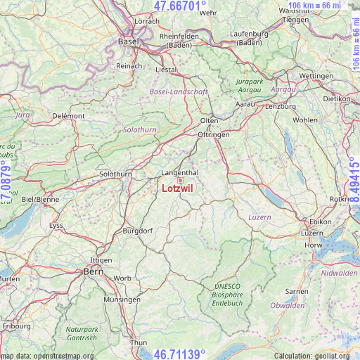
Lotzwil GPS coordinates[2]
47° 11' 28.86" North, 7° 47' 27.672" East
| Map corner | latitude | longitude |
|---|---|---|
| Upper-left | 47.66701°, | 7.0879° |
| Center: | 47.19135°, | 7.79102° |
| Lower-right: | 46.71139°, | 8.49415° |
| Map W x H: | 106.3×106.3 km | = 66.1×66.1mi |
| max Lat: | 47.76737° ⇑53.6% North |
| Lotzwil: | 47.19135° |
| min Lat: | ⇓46.4% South 45.83203° |
| min Long | Lotzwil | max Long |
| 5.97153° | 7.79102° | 10.44624° |
| W 34.1%⇐ | ⇒65.9% E |
Elevation
Elevation of Lotzwil is 500 m = 1640 ft, and this is 58.2 m = 191 ft below average elevation for this country.
| Max E: |
1845 m = 6053 ft | 44.1% |
| Avg. | 558.2 m = 1831 ft | |
| Lotzwil | 500 m = 1640 ft | |
Min E: |
197 m = 646 ft | 55.9% |
See also: Switzerland elevation on elevation.city.
Geographical zone
Lotzwil is located in North temperate zone (between Tropic of Cancer and the Arctic Circle). Distance of this North polar circle is 2154 km =1338.4 mi to North.| Distance of | km | miles | from Lotzwil |
|---|---|---|---|
| North Pole | 4759.9 | 2957.7 | to North |
| Arctic Circle | 2154 | 1338.4 | to North |
| Tropic Cancer | 2641.3 | 1641.2 | to South |
| Equator | 5247.2 | 3260.5 | to South |


Nearby cities:
15 places around Lotzwil: (largest is in red/bold)
• Aarwangen
5.5 km =3.4 mi,  342°
342°
• Auswil
6.9 km =4.3 mi,  152°
152°
• Bannwil
6.8 km =4.2 mi,  322°
322°
• Busswil bei Melchnau
3.2 km =2 mi,  101°
101°
• Herzogenbuchsee
6.4 km =4 mi,  266°
266°
• Kleindietwil
5.1 km =3.2 mi,  181°
181°
• Langenthal
2.7 km =1.7 mi,  8°
8°
• Madiswil
3 km =1.9 mi,  169°
169°
• Melchnau
4.7 km =2.9 mi, 102°
• Oberönz
7.4 km =4.6 mi,  258°
258°
• Ochlenberg
6.2 km =3.9 mi,  221°
221°
• Roggwil
6 km =3.7 mi,  22°
22°
• Rohrbach
6.5 km =4 mi,  164°
164°
• Ursenbach
6.2 km =3.9 mi,  193°
193°
• Wynau
7.4 km =4.6 mi, 14°
Sources, notices
• [Note1] Compared only with cities in Switzerland existing in our database
• [Src1] Map data: © OpenStreetMap contributors (CC-BY-SA)
• [Src2] Other city data from geonames.org with taken over terms of usage.
• [Src3] Geographical zone / Annual Mean Temperature by Robert A. Rohde @ Wikipedia
