Ochlenberg geodata
Ochlenberg (Bern) is a populated place; located in Switzerland in Europe/Zurich (GMT+2) time zone. With population of 641 people, there are 1656 cities with bigger population in this country. Compared to other cities in Switzerland, 56.3% of cities are located further ↑North; 67.4% of cities are located further →East and 69.8% of cities have lower elevation than Ochlenberg. Note1


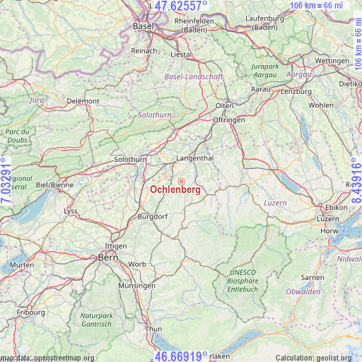
Ochlenberg GPS coordinates[2]
47° 8' 58.308" North, 7° 44' 9.708" East
| Map corner | latitude | longitude |
|---|---|---|
| Upper-left | 47.62557°, | 7.03291° |
| Center: | 47.14953°, | 7.73603° |
| Lower-right: | 46.66919°, | 8.43916° |
| Map W x H: | 106.3×106.3 km | = 66.1×66.1mi |
| max Lat: | 47.76737° ⇑56.3% North |
| Ochlenberg: | 47.14953° |
| min Lat: | ⇓43.7% South 45.83203° |
| min Long | Ochlenberg | max Long |
| 5.97153° | 7.73603° | 10.44624° |
| W 32.6%⇐ | ⇒67.4% E |
Elevation
Elevation of Ochlenberg is 572 m = 1877 ft, and this is 13.8 m = 45 ft above average elevation for this country.
| Max E: |
1845 m = 6053 ft | 30.2% |
| Ochlenberg | 572 m 1877 ft | |
| Avg. | 558.2 m = 1831 ft | |
Min E: |
197 m = 646 ft | 69.8% |
See also: Switzerland elevation on elevation.city.
Geographical zone
Ochlenberg is located in North temperate zone (between Tropic of Cancer and the Arctic Circle). Distance of this North polar circle is 2158.6 km =1341.3 mi to North.| Distance of | km | miles | from Ochlenberg |
|---|---|---|---|
| North Pole | 4764.5 | 2960.5 | to North |
| Arctic Circle | 2158.6 | 1341.3 | to North |
| Tropic Cancer | 2636.6 | 1638.3 | to South |
| Equator | 5242.5 | 3257.5 | to South |


Nearby cities:
15 places around Ochlenberg: (largest is in red/bold)
• Alchenstorf
8 km =5 mi,  250°
250°
• Auswil
7.4 km =4.6 mi,  101°
101°
• Busswil bei Melchnau
8.3 km =5.2 mi,  60°
60°
• Dürrenroth
7.9 km =4.9 mi,  147°
147°
• Herzogenbuchsee
4.8 km =3 mi,  332°
332°
• Kleindietwil
4.1 km =2.5 mi, 95°
• Langenthal
8.6 km =5.3 mi,  31°
31°
• Lotzwil
6.2 km =3.9 mi,  41°
41°
• Madiswil
5 km =3.1 mi,  70°
70°
• Oberönz
4.4 km =2.7 mi,  315°
315°
• Rohrbach
6.1 km =3.8 mi,  105°
105°
• Seeberg
5.4 km =3.4 mi,  277°
277°
• Ursenbach
3.1 km =1.9 mi,  117°
117°
• Walterswil
5.2 km =3.2 mi,  142°
142°
• Wynigen
7.1 km =4.4 mi,  227°
227°
Sources, notices
• [Note1] Compared only with cities in Switzerland existing in our database
• [Src1] Map data: © OpenStreetMap contributors (CC-BY-SA)
• [Src2] Other city data from geonames.org with taken over terms of usage.
• [Src3] Geographical zone / Annual Mean Temperature by Robert A. Rohde @ Wikipedia
