Surpierre geodata
Surpierre (Fribourg) is a seat of a third-order administrative division; located in Switzerland in Europe/Zurich (GMT+2) time zone. In our database, there are 1823 cities with bigger population. Compared to other cities in Switzerland, 76.8% of cities are located further ↑North; 90.4% of cities are located further →East and 50.9% of cities have higher elevation than Surpierre. Note1


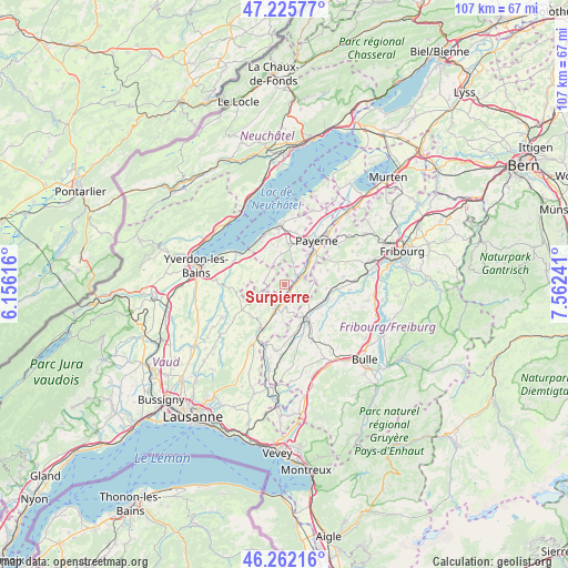
Surpierre GPS coordinates[2]
46° 44' 46.032" North, 6° 51' 33.444" East
| Map corner | latitude | longitude |
|---|---|---|
| Upper-left | 47.22577°, | 6.15616° |
| Center: | 46.74612°, | 6.85929° |
| Lower-right: | 46.26216°, | 7.56241° |
| Map W x H: | 107.1×107.1 km | = 66.5×66.5mi |
| max Lat: | 47.76737° ⇑76.8% North |
| Surpierre: | 46.74612° |
| min Lat: | ⇓23.2% South 45.83203° |
| min Long | Surpierre | max Long |
| 5.97153° | 6.85929° | 10.44624° |
| W 9.6%⇐ | ⇒90.4% E |
Elevation
Elevation of Surpierre is 476 m = 1562 ft, and this is 82.2 m = 270 ft below average elevation for this country.
| Max E: |
1845 m = 6053 ft | 50.9% |
| Avg. | 558.2 m = 1831 ft | |
| Surpierre | 476 m = 1562 ft | |
Min E: |
197 m = 646 ft | 49.1% |
See also: Switzerland elevation on elevation.city.
Geographical zone
Surpierre is located in North temperate zone (between Tropic of Cancer and the Arctic Circle). Distance of this North polar circle is 2203.5 km =1369.2 mi to North.| Distance of | km | miles | from Surpierre |
|---|---|---|---|
| North Pole | 4809.4 | 2988.4 | to North |
| Arctic Circle | 2203.5 | 1369.2 | to North |
| Tropic Cancer | 2591.8 | 1610.5 | to South |
| Equator | 5197.7 | 3229.7 | to South |


Nearby cities:
15 places around Surpierre: (largest is in red/bold)
• Cheyres
9.4 km =5.8 mi,  323°
323°
• Cugy
8 km =5 mi,  16°
16°
• Estavayer-le-Lac
11.5 km =7.1 mi,  355°
355°
• Granges
2.8 km =1.7 mi,  50°
50°
• Lucens
4.4 km =2.7 mi,  200°
200°
• Lully
9.8 km =6.1 mi,  353°
353°
• Moudon
9.9 km =6.2 mi,  208°
208°
• Mézières
9 km =5.6 mi,  145°
145°
• Payerne
10.3 km =6.4 mi,  35°
35°
• Romont
7.1 km =4.4 mi,  140°
140°
• Siviriez
9.8 km =6.1 mi,  171°
171°
• Thierrens
9.2 km =5.7 mi,  239°
239°
• Villaz-Saint-Pierre
7.9 km =4.9 mi,  110°
110°
• Vuisternens-devant-Romont
11.6 km =7.2 mi, 152°
• Yvonand
10.7 km =6.6 mi,  304°
304°
Sources, notices
• [Note1] Compared only with cities in Switzerland existing in our database
• [Src1] Map data: © OpenStreetMap contributors (CC-BY-SA)
• [Src2] Other city data from geonames.org with taken over terms of usage.
• [Src3] Geographical zone / Annual Mean Temperature by Robert A. Rohde @ Wikipedia
