Rechthalten geodata
Rechthalten (Fribourg) is a populated place; located in Switzerland in Europe/Zurich (GMT+2) time zone. With population of 1,058 people, there are 1293 cities with bigger population in this country. Compared to other cities in Switzerland, 76% of cities are located further ↑North; 81.1% of cities are located further →East and 92.1% of cities have lower elevation than Rechthalten. Note1


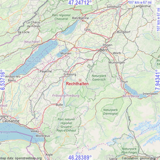
Rechthalten GPS coordinates[2]
46° 46' 3.576" North, 7° 14' 25.008" East
| Map corner | latitude | longitude |
|---|---|---|
| Upper-left | 47.24712°, | 6.53716° |
| Center: | 46.76766°, | 7.24028° |
| Lower-right: | 46.28389°, | 7.94341° |
| Map W x H: | 107.1×107.1 km | = 66.5×66.5mi |
| max Lat: | 47.76737° ⇑76% North |
| Rechthalten: | 46.76766° |
| min Lat: | ⇓24% South 45.83203° |
| min Long | Rechthalten | max Long |
| 5.97153° | 7.24028° | 10.44624° |
| W 18.9%⇐ | ⇒81.1% E |
Elevation
Elevation of Rechthalten is 881 m = 2890 ft, and this is 322.8 m = 1059 ft above average elevation for this country.
| Max E: |
1845 m = 6053 ft | 7.9% |
| Rechthalten | 881 m 2890 ft | |
| Avg. | 558.2 m = 1831 ft | |
Min E: |
197 m = 646 ft | 92.1% |
See also: Switzerland elevation on elevation.city.
Geographical zone
Rechthalten is located in North temperate zone (between Tropic of Cancer and the Arctic Circle). Distance of this North polar circle is 2201.1 km =1367.7 mi to North.| Distance of | km | miles | from Rechthalten |
|---|---|---|---|
| North Pole | 4807 | 2986.9 | to North |
| Arctic Circle | 2201.1 | 1367.7 | to North |
| Tropic Cancer | 2594.2 | 1612 | to South |
| Equator | 5200.1 | 3231.2 | to South |


Nearby cities:
15 places around Rechthalten: (largest is in red/bold)
• Alterswil
3.4 km =2.1 mi,  24°
24°
• Arconciel
9.3 km =5.8 mi,  255°
255°
• Ependes
7.3 km =4.5 mi, 257°
• Fribourg
7.8 km =4.8 mi,  299°
299°
• Giffers
2.5 km =1.6 mi, 256°
• Guggisberg
6.8 km =4.2 mi,  90°
90°
• Heitenried
8 km =5 mi,  34°
34°
• Marly
5.8 km =3.6 mi,  279°
279°
• Oberschrot
4.3 km =2.7 mi,  133°
133°
• Plaffeien
4.5 km =2.8 mi, 128°
• Plasselb
3.7 km =2.3 mi,  167°
167°
• Praroman
5.1 km =3.2 mi,  249°
249°
• Sankt Antoni
6.3 km =3.9 mi,  14°
14°
• Tafers
5.5 km =3.4 mi,  342°
342°
• Treyvaux
9 km =5.6 mi,  240°
240°
Sources, notices
• [Note1] Compared only with cities in Switzerland existing in our database
• [Src1] Map data: © OpenStreetMap contributors (CC-BY-SA)
• [Src2] Other city data from geonames.org with taken over terms of usage.
• [Src3] Geographical zone / Annual Mean Temperature by Robert A. Rohde @ Wikipedia
