Täsch geodata
Täsch (Valais) is a populated place; located in Switzerland in Europe/Zurich (GMT+2) time zone. With population of 831 people, there are 1473 cities with bigger population in this country. Compared to other cities in Switzerland, 97.8% of cities are located further ↑North; 66.3% of cities are located further →East and 98.7% of cities have lower elevation than Täsch. Note1


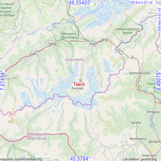
Täsch GPS coordinates[2]
46° 4' 6.168" North, 7° 46' 39.576" East
| Map corner | latitude | longitude |
|---|---|---|
| Upper-left | 46.55405°, | 7.07454° |
| Center: | 46.06838°, | 7.77766° |
| Lower-right: | 45.5784°, | 8.48079° |
| Map W x H: | 108.5×108.5 km | = 67.4×67.4mi |
| max Lat: | 47.76737° ⇑97.8% North |
| Täsch: | 46.06838° |
| min Lat: | ⇓2.2% South 45.83203° |
| min Long | Täsch | max Long |
| 5.97153° | 7.77766° | 10.44624° |
| W 33.7%⇐ | ⇒66.3% E |
Elevation
Elevation of Täsch is 1441 m = 4728 ft, and this is 882.8 m = 2896 ft above average elevation for this country.
| Max E: |
1845 m = 6053 ft | 1.3% |
| Täsch | 1441 m 4728 ft | |
| Avg. | 558.2 m = 1831 ft | |
Min E: |
197 m = 646 ft | 98.7% |
See also: Switzerland elevation on elevation.city.
Geographical zone
Täsch is located in North temperate zone (between Tropic of Cancer and the Arctic Circle). Distance of this North polar circle is 2278.9 km =1416 mi to North.| Distance of | km | miles | from Täsch |
|---|---|---|---|
| North Pole | 4884.7 | 3035.2 | to North |
| Arctic Circle | 2278.9 | 1416 | to North |
| Tropic Cancer | 2516.4 | 1563.6 | to South |
| Equator | 5122.3 | 3182.8 | to South |


Nearby cities:
15 places around Täsch: (largest is in red/bold)
• Ayer
18.5 km =11.5 mi,  312°
312°
• Bürchen
23.8 km =14.8 mi,  6°
6°
• Eischoll
25 km =15.5 mi,  0°
0°
• Evolène
22.5 km =14 mi,  283°
283°
• Grächen
14.8 km =9.2 mi,  18°
18°
• Saas-Fee
12.4 km =7.7 mi,  69°
69°
• Saas-Grund
13.7 km =8.5 mi,  63°
63°
• Sankt Niklaus
12.3 km =7.6 mi, 9°
• Stalden
19.8 km =12.3 mi, 21°
• Staldenried
19.6 km =12.2 mi, 24°
• Turtmann
26.4 km =16.4 mi,  347°
347°
• Törbel
19.8 km =12.3 mi, 16°
• Visp
26.3 km =16.3 mi, 17°
• Visperterminen
23.3 km =14.5 mi, 24°
• Zermatt
5.8 km =3.6 mi,  202°
202°
Sources, notices
• [Note1] Compared only with cities in Switzerland existing in our database
• [Src1] Map data: © OpenStreetMap contributors (CC-BY-SA)
• [Src2] Other city data from geonames.org with taken over terms of usage.
• [Src3] Geographical zone / Annual Mean Temperature by Robert A. Rohde @ Wikipedia
