Eischoll geodata
Eischoll (Valais) is a populated place; located in Switzerland in Europe/Zurich (GMT+2) time zone. With population of 513 people, there are 1785 cities with bigger population in this country. Compared to other cities in Switzerland, 91.1% of cities are located further ↑North; 66.2% of cities are located further →East and 97.6% of cities have lower elevation than Eischoll. Note1


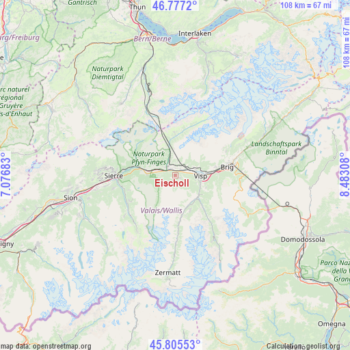
Eischoll GPS coordinates[2]
46° 17' 36.672" North, 7° 46' 47.82" East
| Map corner | latitude | longitude |
|---|---|---|
| Upper-left | 46.7772°, | 7.07683° |
| Center: | 46.29352°, | 7.77995° |
| Lower-right: | 45.80553°, | 8.48308° |
| Map W x H: | 108×108 km | = 67.1×67.1mi |
| max Lat: | 47.76737° ⇑91.1% North |
| Eischoll: | 46.29352° |
| min Lat: | ⇓8.9% South 45.83203° |
| min Long | Eischoll | max Long |
| 5.97153° | 7.77995° | 10.44624° |
| W 33.8%⇐ | ⇒66.2% E |
Elevation
Elevation of Eischoll is 1239 m = 4065 ft, and this is 680.8 m = 2234 ft above average elevation for this country.
| Max E: |
1845 m = 6053 ft | 2.4% |
| Eischoll | 1239 m 4065 ft | |
| Avg. | 558.2 m = 1831 ft | |
Min E: |
197 m = 646 ft | 97.6% |
See also: Switzerland elevation on elevation.city.
Geographical zone
Eischoll is located in North temperate zone (between Tropic of Cancer and the Arctic Circle). Distance of this North polar circle is 2253.8 km =1400.4 mi to North.| Distance of | km | miles | from Eischoll |
|---|---|---|---|
| North Pole | 4859.7 | 3019.7 | to North |
| Arctic Circle | 2253.8 | 1400.4 | to North |
| Tropic Cancer | 2541.4 | 1579.2 | to South |
| Equator | 5147.4 | 3198.4 | to South |


Nearby cities:
15 places around Eischoll: (largest is in red/bold)
• Agarn
9 km =5.6 mi,  272°
272°
• Baltschieder
6.8 km =4.2 mi,  75°
75°
• Bürchen
3.1 km =1.9 mi,  118°
118°
• Gampel
3.8 km =2.4 mi,  310°
310°
• Grächen
11.8 km =7.3 mi,  157°
157°
• Lalden
9.4 km =5.8 mi,  85°
85°
• Leuk
11.5 km =7.1 mi,  283°
283°
• Niedergesteln
2.1 km =1.3 mi,  7°
7°
• Raron
2.6 km =1.6 mi,  37°
37°
• Stalden
9.8 km =6.1 mi,  133°
133°
• Staldenried
10.6 km =6.6 mi, 132°
• Turtmann
6 km =3.7 mi, 277°
• Törbel
8.3 km =5.2 mi,  137°
137°
• Visp
7.8 km =4.8 mi, 89°
• Visperterminen
10.1 km =6.3 mi,  112°
112°
Sources, notices
• [Note1] Compared only with cities in Switzerland existing in our database
• [Src1] Map data: © OpenStreetMap contributors (CC-BY-SA)
• [Src2] Other city data from geonames.org with taken over terms of usage.
• [Src3] Geographical zone / Annual Mean Temperature by Robert A. Rohde @ Wikipedia
