Staldenried geodata
Staldenried (Valais) is a populated place; located in Switzerland in Europe/Zurich (GMT+2) time zone. With population of 589 people, there are 1703 cities with bigger population in this country. Compared to other cities in Switzerland, 93.2% of cities are located further ↑North; 63% of cities are located further →East and 96.4% of cities have lower elevation than Staldenried. Note1


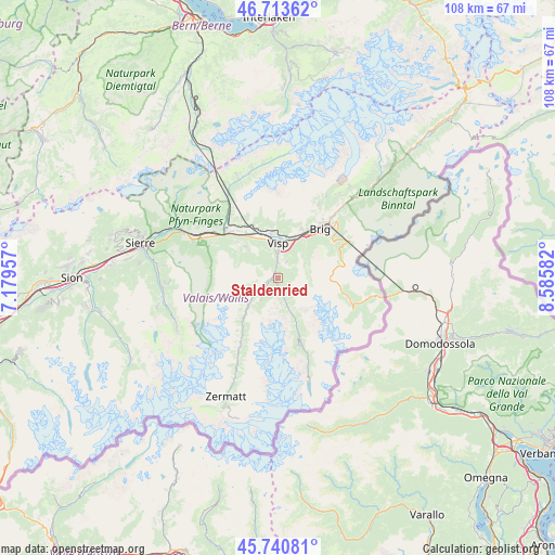
Staldenried GPS coordinates[2]
46° 13' 45.732" North, 7° 52' 57.684" East
| Map corner | latitude | longitude |
|---|---|---|
| Upper-left | 46.71362°, | 7.17957° |
| Center: | 46.22937°, | 7.88269° |
| Lower-right: | 45.74081°, | 8.58582° |
| Map W x H: | 108.2×108.2 km | = 67.2×67.2mi |
| max Lat: | 47.76737° ⇑93.2% North |
| Staldenried: | 46.22937° |
| min Lat: | ⇓6.8% South 45.83203° |
| min Long | Staldenried | max Long |
| 5.97153° | 7.88269° | 10.44624° |
| W 37%⇐ | ⇒63% E |
Elevation
Elevation of Staldenried is 1089 m = 3573 ft, and this is 530.8 m = 1741 ft above average elevation for this country.
| Max E: |
1845 m = 6053 ft | 3.6% |
| Staldenried | 1089 m 3573 ft | |
| Avg. | 558.2 m = 1831 ft | |
Min E: |
197 m = 646 ft | 96.4% |
See also: Switzerland elevation on elevation.city.
Geographical zone
Staldenried is located in North temperate zone (between Tropic of Cancer and the Arctic Circle). Distance of this North polar circle is 2260.9 km =1404.9 mi to North.| Distance of | km | miles | from Staldenried |
|---|---|---|---|
| North Pole | 4866.8 | 3024.1 | to North |
| Arctic Circle | 2260.9 | 1404.9 | to North |
| Tropic Cancer | 2534.3 | 1574.7 | to South |
| Equator | 5140.2 | 3194 | to South |


Nearby cities:
15 places around Staldenried: (largest is in red/bold)
• Baltschieder
8.9 km =5.5 mi,  351°
351°
• Brig
12.4 km =7.7 mi,  38°
38°
• Bürchen
7.7 km =4.8 mi,  317°
317°
• Eischoll
10.6 km =6.6 mi,  312°
312°
• Grächen
5.1 km =3.2 mi,  222°
222°
• Lalden
7.9 km =4.9 mi,  10°
10°
• Mund
10.5 km =6.5 mi,  25°
25°
• Niedergesteln
12 km =7.5 mi, 320°
• Raron
11.2 km =7 mi,  325°
325°
• Saas-Grund
12.6 km =7.8 mi,  160°
160°
• Sankt Niklaus
8.4 km =5.2 mi,  226°
226°
• Stalden
0.9 km =0.6 mi,  300°
300°
• Törbel
2.5 km =1.6 mi,  293°
293°
• Visp
7.2 km =4.5 mi,  359°
359°
• Visperterminen
3.6 km =2.2 mi,  24°
24°
Sources, notices
• [Note1] Compared only with cities in Switzerland existing in our database
• [Src1] Map data: © OpenStreetMap contributors (CC-BY-SA)
• [Src2] Other city data from geonames.org with taken over terms of usage.
• [Src3] Geographical zone / Annual Mean Temperature by Robert A. Rohde @ Wikipedia
