Saint-Ursanne geodata
Saint-Ursanne (Jura) is a populated place; located in Switzerland in Europe/Zurich (GMT+2) time zone. With population of 683 people, there are 1618 cities with bigger population in this country. Compared to other cities in Switzerland, 66.8% of cities are located further ↓South; 83.1% of cities are located further →East and 65.9% of cities have higher elevation than Saint-Ursanne. Note1


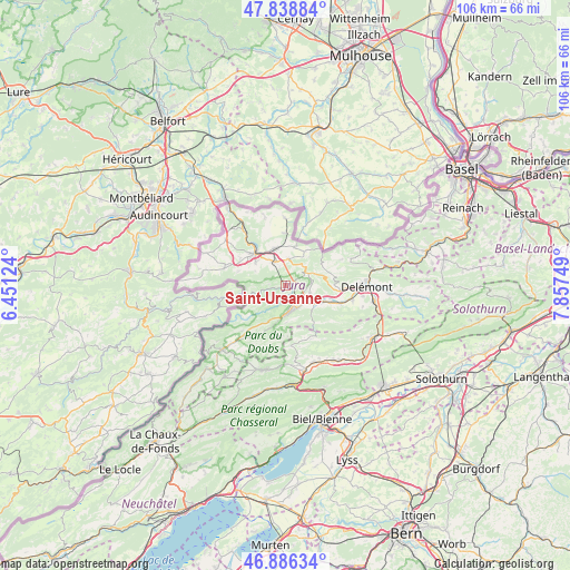
Saint-Ursanne GPS coordinates[2]
47° 21' 53.064" North, 7° 9' 15.696" East
| Map corner | latitude | longitude |
|---|---|---|
| Upper-left | 47.83884°, | 6.45124° |
| Center: | 47.36474°, | 7.15436° |
| Lower-right: | 46.88634°, | 7.85749° |
| Map W x H: | 105.9×105.9 km | = 65.8×65.8mi |
| max Lat: | 47.76737° ⇑33.2% North |
| Saint-Ursanne: | 47.36474° |
| min Lat: | ⇓66.8% South 45.83203° |
| min Long | Saint-Ursanne | max Long |
| 5.97153° | 7.15436° | 10.44624° |
| W 16.9%⇐ | ⇒83.1% E |
Elevation
Elevation of Saint-Ursanne is 445 m = 1460 ft, and this is 113.2 m = 371 ft below average elevation for this country.
| Max E: |
1845 m = 6053 ft | 65.9% |
| Avg. | 558.2 m = 1831 ft | |
| Saint-Ursanne | 445 m = 1460 ft | |
Min E: |
197 m = 646 ft | 34.1% |
See also: Switzerland elevation on elevation.city.
Geographical zone
Saint-Ursanne is located in North temperate zone (between Tropic of Cancer and the Arctic Circle). Distance of this North polar circle is 2134.7 km =1326.4 mi to North.| Distance of | km | miles | from Saint-Ursanne |
|---|---|---|---|
| North Pole | 4740.6 | 2945.7 | to North |
| Arctic Circle | 2134.7 | 1326.4 | to North |
| Tropic Cancer | 2660.5 | 1653.2 | to South |
| Equator | 5266.5 | 3272.5 | to South |


Nearby cities:
15 places around Saint-Ursanne: (largest is in red/bold)
• Alle
7 km =4.3 mi,  344°
344°
• Bassecourt
7.4 km =4.6 mi,  113°
113°
• Bonfol
12.5 km =7.8 mi,  359°
359°
• Chevenez
12 km =7.5 mi,  285°
285°
• Coeuve
10.6 km =6.6 mi, 337°
• Cornol
4.8 km =3 mi,  7°
7°
• Courfaivre
10.2 km =6.3 mi, 109°
• Courgenay
5 km =3.1 mi,  333°
333°
• Courtedoux
9.8 km =6.1 mi,  299°
299°
• Courtételle
12.6 km =7.8 mi,  102°
102°
• Fontenais
7 km =4.3 mi,  307°
307°
• Glovelier
5.1 km =3.2 mi,  130°
130°
• Lajoux
9.6 km =6 mi,  187°
187°
• Porrentruy
8.3 km =5.2 mi, 314°
• Vendlincourt
9.8 km =6.1 mi, 358°
Sources, notices
• [Note1] Compared only with cities in Switzerland existing in our database
• [Src1] Map data: © OpenStreetMap contributors (CC-BY-SA)
• [Src2] Other city data from geonames.org with taken over terms of usage.
• [Src3] Geographical zone / Annual Mean Temperature by Robert A. Rohde @ Wikipedia
