Chevenez geodata
Chevenez (Jura) is a populated place; located in Switzerland in Europe/Zurich (GMT+2) time zone. With population of 583 people, there are 1709 cities with bigger population in this country. Compared to other cities in Switzerland, 71.8% of cities are located further ↓South; 87.7% of cities are located further →East and 50.3% of cities have higher elevation than Chevenez. Note1


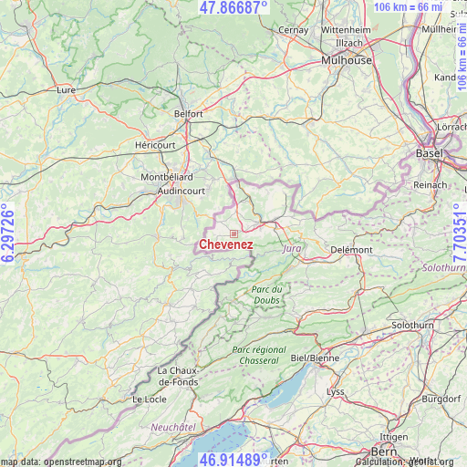
Chevenez GPS coordinates[2]
47° 23' 34.908" North, 7° 0' 1.368" East
| Map corner | latitude | longitude |
|---|---|---|
| Upper-left | 47.86687°, | 6.29726° |
| Center: | 47.39303°, | 7.00038° |
| Lower-right: | 46.91489°, | 7.70351° |
| Map W x H: | 105.9×105.8 km | = 65.8×65.7mi |
| max Lat: | 47.76737° ⇑28.2% North |
| Chevenez: | 47.39303° |
| min Lat: | ⇓71.8% South 45.83203° |
| min Long | Chevenez | max Long |
| 5.97153° | 7.00038° | 10.44624° |
| W 12.3%⇐ | ⇒87.7% E |
Elevation
Elevation of Chevenez is 477 m = 1565 ft, and this is 81.2 m = 266 ft below average elevation for this country.
| Max E: |
1845 m = 6053 ft | 50.3% |
| Avg. | 558.2 m = 1831 ft | |
| Chevenez | 477 m = 1565 ft | |
Min E: |
197 m = 646 ft | 49.7% |
See also: Switzerland elevation on elevation.city.
Geographical zone
Chevenez is located in North temperate zone (between Tropic of Cancer and the Arctic Circle). Distance of this North polar circle is 2131.6 km =1324.5 mi to North.| Distance of | km | miles | from Chevenez |
|---|---|---|---|
| North Pole | 4737.5 | 2943.7 | to North |
| Arctic Circle | 2131.6 | 1324.5 | to North |
| Tropic Cancer | 2663.7 | 1655.1 | to South |
| Equator | 5269.6 | 3274.4 | to South |


Nearby cities:
15 places around Chevenez: (largest is in red/bold)
• Alle
10.4 km =6.5 mi,  69°
69°
• Boncourt
11.4 km =7.1 mi,  4°
4°
• Bonfol
14.8 km =9.2 mi,  50°
50°
• Coeuve
10 km =6.2 mi, 48°
• Cornol
12.3 km =7.6 mi,  82°
82°
• Courgenay
9.5 km =5.9 mi, 82°
• Courtedoux
3.5 km =2.2 mi,  61°
61°
• Courtemaîche
8 km =5 mi,  26°
26°
• Fontenais
6.2 km =3.9 mi, 79°
• Glovelier
16.7 km =10.4 mi,  112°
112°
• Lajoux
16.4 km =10.2 mi,  140°
140°
• Porrentruy
6.3 km =3.9 mi, 64°
• Saignelégier
15.2 km =9.4 mi,  181°
181°
• Saint-Ursanne
12 km =7.5 mi, 105°
• Vendlincourt
13.1 km =8.1 mi, 59°
Sources, notices
• [Note1] Compared only with cities in Switzerland existing in our database
• [Src1] Map data: © OpenStreetMap contributors (CC-BY-SA)
• [Src2] Other city data from geonames.org with taken over terms of usage.
• [Src3] Geographical zone / Annual Mean Temperature by Robert A. Rohde @ Wikipedia
