Bonfol geodata
Bonfol (Jura) is a populated place; located in Switzerland in Europe/Zurich (GMT+2) time zone. With population of 617 people, there are 1675 cities with bigger population in this country. Compared to other cities in Switzerland, 85.9% of cities are located further ↓South; 83.2% of cities are located further →East and 71.5% of cities have higher elevation than Bonfol. Note1


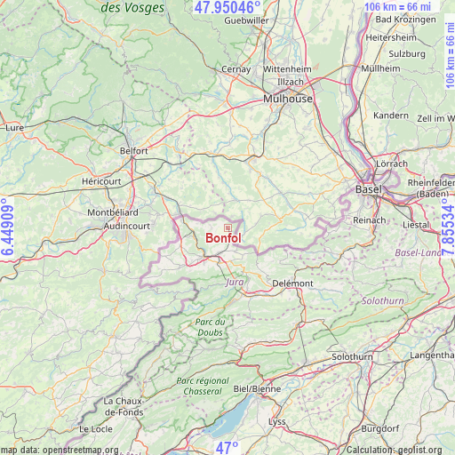
Bonfol GPS coordinates[2]
47° 28' 38.568" North, 7° 9' 7.956" East
| Map corner | latitude | longitude |
|---|---|---|
| Upper-left | 47.95046°, | 6.44909° |
| Center: | 47.47738°, | 7.15221° |
| Lower-right: | 47°, | 7.85534° |
| Map W x H: | 105.7×105.7 km | = 65.7×65.7mi |
| max Lat: | 47.76737° ⇑14.1% North |
| Bonfol: | 47.47738° |
| min Lat: | ⇓85.9% South 45.83203° |
| min Long | Bonfol | max Long |
| 5.97153° | 7.15221° | 10.44624° |
| W 16.8%⇐ | ⇒83.2% E |
Elevation
Elevation of Bonfol is 437 m = 1434 ft, and this is 121.2 m = 398 ft below average elevation for this country.
| Max E: |
1845 m = 6053 ft | 71.5% |
| Avg. | 558.2 m = 1831 ft | |
| Bonfol | 437 m = 1434 ft | |
Min E: |
197 m = 646 ft | 28.5% |
See also: Switzerland elevation on elevation.city.
Geographical zone
Bonfol is located in North temperate zone (between Tropic of Cancer and the Arctic Circle). Distance of this North polar circle is 2122.2 km =1318.7 mi to North.| Distance of | km | miles | from Bonfol |
|---|---|---|---|
| North Pole | 4728.1 | 2937.9 | to North |
| Arctic Circle | 2122.2 | 1318.7 | to North |
| Tropic Cancer | 2673.1 | 1661 | to South |
| Equator | 5279 | 3280.2 | to South |


Nearby cities:
15 places around Bonfol: (largest is in red/bold)
• Alle
6 km =3.7 mi,  195°
195°
• Bassecourt
17 km =10.6 mi,  156°
156°
• Boncourt
10.6 km =6.6 mi,  280°
280°
• Chevenez
14.8 km =9.2 mi,  230°
230°
• Coeuve
4.8 km =3 mi, 234°
• Cornol
7.8 km =4.8 mi,  174°
174°
• Courfaivre
18.6 km =11.6 mi,  148°
148°
• Courgenay
8.3 km =5.2 mi,  194°
194°
• Courtedoux
11.4 km =7.1 mi, 227°
• Courtemaîche
8.1 km =5 mi,  254°
254°
• Fontenais
9.9 km =6.2 mi,  212°
212°
• Glovelier
16.3 km =10.1 mi, 165°
• Porrentruy
8.8 km =5.5 mi,  220°
220°
• Saint-Ursanne
12.5 km =7.8 mi,  179°
179°
• Vendlincourt
2.8 km =1.7 mi, 181°
Sources, notices
• [Note1] Compared only with cities in Switzerland existing in our database
• [Src1] Map data: © OpenStreetMap contributors (CC-BY-SA)
• [Src2] Other city data from geonames.org with taken over terms of usage.
• [Src3] Geographical zone / Annual Mean Temperature by Robert A. Rohde @ Wikipedia
