Rüeggisberg geodata
Rüeggisberg (Bern) is a populated place; located in Switzerland in Europe/Zurich (GMT+2) time zone. With population of 1,933 people, there are 862 cities with bigger population in this country. Compared to other cities in Switzerland, 73% of cities are located further ↑North; 77.2% of cities are located further →East and 93.6% of cities have lower elevation than Rüeggisberg. Note1


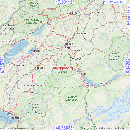
Rüeggisberg GPS coordinates[2]
46° 49' 19.776" North, 7° 26' 20.04" East
| Map corner | latitude | longitude |
|---|---|---|
| Upper-left | 47.30113°, | 6.73577° |
| Center: | 46.82216°, | 7.4389° |
| Lower-right: | 46.33888°, | 8.14202° |
| Map W x H: | 107×107 km | = 66.5×66.5mi |
| max Lat: | 47.76737° ⇑73% North |
| Rüeggisberg: | 46.82216° |
| min Lat: | ⇓27% South 45.83203° |
| min Long | Rüeggisberg | max Long |
| 5.97153° | 7.4389° | 10.44624° |
| W 22.8%⇐ | ⇒77.2% E |
Elevation
Elevation of Rüeggisberg is 944 m = 3097 ft, and this is 385.8 m = 1266 ft above average elevation for this country.
| Max E: |
1845 m = 6053 ft | 6.4% |
| Rüeggisberg | 944 m 3097 ft | |
| Avg. | 558.2 m = 1831 ft | |
Min E: |
197 m = 646 ft | 93.6% |
See also: Switzerland elevation on elevation.city.
Geographical zone
Rüeggisberg is located in North temperate zone (between Tropic of Cancer and the Arctic Circle). Distance of this North polar circle is 2195 km =1363.9 mi to North.| Distance of | km | miles | from Rüeggisberg |
|---|---|---|---|
| North Pole | 4800.9 | 2983.1 | to North |
| Arctic Circle | 2195 | 1363.9 | to North |
| Tropic Cancer | 2600.2 | 1615.7 | to South |
| Equator | 5206.1 | 3234.9 | to South |


Nearby cities:
15 places around Rüeggisberg: (largest is in red/bold)
• Belp
8.9 km =5.5 mi,  30°
30°
• Burgistein
6.2 km =3.9 mi,  131°
131°
• Gerzensee
8.3 km =5.2 mi,  76°
76°
• Hermiswil
3.1 km =1.9 mi,  71°
71°
• Kirchdorf
8.3 km =5.2 mi,  91°
91°
• Mühlethurnen
5.4 km =3.4 mi,  100°
100°
• Niedermuhlern
4.6 km =2.9 mi, 27°
• Oberbalm
6.3 km =3.9 mi,  334°
334°
• Riggisberg
3.4 km =2.1 mi,  112°
112°
• Rümligen
4.4 km =2.7 mi, 78°
• Rüschegg
5.9 km =3.7 mi,  217°
217°
• Seftigen
8.6 km =5.3 mi,  116°
116°
• Toffen
5.9 km =3.7 mi,  43°
43°
• Wattenwil
7.9 km =4.9 mi,  137°
137°
• Zimmerwald
7.2 km =4.5 mi,  23°
23°
Sources, notices
• [Note1] Compared only with cities in Switzerland existing in our database
• [Src1] Map data: © OpenStreetMap contributors (CC-BY-SA)
• [Src2] Other city data from geonames.org with taken over terms of usage.
• [Src3] Geographical zone / Annual Mean Temperature by Robert A. Rohde @ Wikipedia
