Niedermuhlern geodata
Niedermuhlern (Bern) is a seat of a third-order administrative division; located in Switzerland in Europe/Zurich (GMT+2) time zone. In our database, there are 1823 cities with bigger population. Compared to other cities in Switzerland, 71.6% of cities are located further ↑North; 76.5% of cities are located further →East and 90.6% of cities have lower elevation than Niedermuhlern. Note1


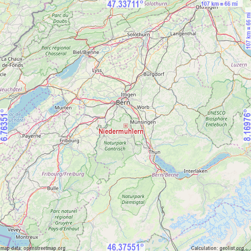
Niedermuhlern GPS coordinates[2]
46° 51' 30.456" North, 7° 27' 59.868" East
| Map corner | latitude | longitude |
|---|---|---|
| Upper-left | 47.33711°, | 6.76351° |
| Center: | 46.85846°, | 7.46663° |
| Lower-right: | 46.37551°, | 8.16976° |
| Map W x H: | 106.9×106.9 km | = 66.4×66.4mi |
| max Lat: | 47.76737° ⇑71.6% North |
| Niedermuhlern: | 46.85846° |
| min Lat: | ⇓28.4% South 45.83203° |
| min Long | Niedermuhlern | max Long |
| 5.97153° | 7.46663° | 10.44624° |
| W 23.5%⇐ | ⇒76.5% E |
Elevation
Elevation of Niedermuhlern is 839 m = 2753 ft, and this is 280.8 m = 921 ft above average elevation for this country.
| Max E: |
1845 m = 6053 ft | 9.4% |
| Niedermuhlern | 839 m 2753 ft | |
| Avg. | 558.2 m = 1831 ft | |
Min E: |
197 m = 646 ft | 90.6% |
See also: Switzerland elevation on elevation.city.
Geographical zone
Niedermuhlern is located in North temperate zone (between Tropic of Cancer and the Arctic Circle). Distance of this North polar circle is 2191 km =1361.4 mi to North.| Distance of | km | miles | from Niedermuhlern |
|---|---|---|---|
| North Pole | 4796.9 | 2980.7 | to North |
| Arctic Circle | 2191 | 1361.4 | to North |
| Tropic Cancer | 2604.3 | 1618.2 | to South |
| Equator | 5210.2 | 3237.5 | to South |


Nearby cities:
15 places around Niedermuhlern: (largest is in red/bold)
• Belp
4.4 km =2.7 mi,  33°
33°
• Gerzensee
6.3 km =3.9 mi,  108°
108°
• Hermiswil
3.1 km =1.9 mi,  164°
164°
• Kehrsatz
5.8 km =3.6 mi,  3°
3°
• Kirchdorf
7.5 km =4.7 mi,  123°
123°
• Muri
8.2 km =5.1 mi,  10°
10°
• Mühlethurnen
5.9 km =3.7 mi,  147°
147°
• Münsingen
7.4 km =4.6 mi,  77°
77°
• Oberbalm
5.1 km =3.2 mi,  289°
289°
• Riggisberg
5.5 km =3.4 mi,  169°
169°
• Rubigen
7.4 km =4.6 mi,  52°
52°
• Rüeggisberg
4.6 km =2.9 mi,  207°
207°
• Rümligen
3.9 km =2.4 mi, 145°
• Toffen
2 km =1.2 mi, 83°
• Zimmerwald
2.6 km =1.6 mi,  17°
17°
Sources, notices
• [Note1] Compared only with cities in Switzerland existing in our database
• [Src1] Map data: © OpenStreetMap contributors (CC-BY-SA)
• [Src2] Other city data from geonames.org with taken over terms of usage.
• [Src3] Geographical zone / Annual Mean Temperature by Robert A. Rohde @ Wikipedia
