Riggisberg geodata
Riggisberg (Bern) is a populated place; located in Switzerland in Europe/Zurich (GMT+2) time zone. With population of 2,001 people, there are 831 cities with bigger population in this country. Compared to other cities in Switzerland, 74.1% of cities are located further ↑North; 76.2% of cities are located further →East and 87% of cities have lower elevation than Riggisberg. Note1


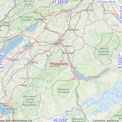
Riggisberg GPS coordinates[2]
46° 48' 37.008" North, 7° 28' 48.504" East
| Map corner | latitude | longitude |
|---|---|---|
| Upper-left | 47.28936°, | 6.77702° |
| Center: | 46.81028°, | 7.48014° |
| Lower-right: | 46.3269°, | 8.18327° |
| Map W x H: | 107×107 km | = 66.5×66.5mi |
| max Lat: | 47.76737° ⇑74.1% North |
| Riggisberg: | 46.81028° |
| min Lat: | ⇓25.9% South 45.83203° |
| min Long | Riggisberg | max Long |
| 5.97153° | 7.48014° | 10.44624° |
| W 23.8%⇐ | ⇒76.2% E |
Elevation
Elevation of Riggisberg is 764 m = 2507 ft, and this is 205.8 m = 675 ft above average elevation for this country.
| Max E: |
1845 m = 6053 ft | 13% |
| Riggisberg | 764 m 2507 ft | |
| Avg. | 558.2 m = 1831 ft | |
Min E: |
197 m = 646 ft | 87% |
See also: Switzerland elevation on elevation.city.
Geographical zone
Riggisberg is located in North temperate zone (between Tropic of Cancer and the Arctic Circle). Distance of this North polar circle is 2196.4 km =1364.8 mi to North.| Distance of | km | miles | from Riggisberg |
|---|---|---|---|
| North Pole | 4802.2 | 2983.9 | to North |
| Arctic Circle | 2196.4 | 1364.8 | to North |
| Tropic Cancer | 2598.9 | 1614.9 | to South |
| Equator | 5204.8 | 3234.1 | to South |


Nearby cities:
15 places around Riggisberg: (largest is in red/bold)
• Burgistein
3.2 km =2 mi,  152°
152°
• Gerzensee
6 km =3.7 mi,  55°
55°
• Hermiswil
2.3 km =1.4 mi,  355°
355°
• Kiesen
8 km =5 mi,  82°
82°
• Kirchdorf
5.3 km =3.3 mi, 77°
• Mühlethurnen
2.2 km =1.4 mi, 80°
• Niedermuhlern
5.5 km =3.4 mi,  349°
349°
• Rüeggisberg
3.4 km =2.1 mi,  292°
292°
• Rümligen
2.5 km =1.6 mi,  28°
28°
• Rüschegg
7.5 km =4.7 mi,  243°
243°
• Seftigen
5.2 km =3.2 mi,  119°
119°
• Toffen
5.6 km =3.5 mi,  9°
9°
• Uttigen
7.6 km =4.7 mi,  103°
103°
• Wattenwil
5 km =3.1 mi, 154°
• Zimmerwald
7.9 km =4.9 mi, 358°
Sources, notices
• [Note1] Compared only with cities in Switzerland existing in our database
• [Src1] Map data: © OpenStreetMap contributors (CC-BY-SA)
• [Src2] Other city data from geonames.org with taken over terms of usage.
• [Src3] Geographical zone / Annual Mean Temperature by Robert A. Rohde @ Wikipedia
