Rümligen geodata
Rümligen (Bern) is a seat of a third-order administrative division; located in Switzerland in Europe/Zurich (GMT+2) time zone. In our database, there are 1823 cities with bigger population. Compared to other cities in Switzerland, 72.8% of cities are located further ↑North; 75.7% of cities are located further →East and 69.4% of cities have lower elevation than Rümligen. Note1


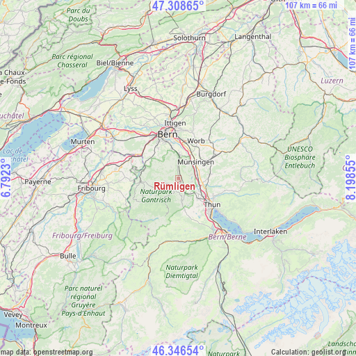
Rümligen GPS coordinates[2]
46° 49' 47.1" North, 7° 29' 43.512" East
| Map corner | latitude | longitude |
|---|---|---|
| Upper-left | 47.30865°, | 6.7923° |
| Center: | 46.82975°, | 7.49542° |
| Lower-right: | 46.34654°, | 8.19855° |
| Map W x H: | 107×107 km | = 66.5×66.5mi |
| max Lat: | 47.76737° ⇑72.8% North |
| Rümligen: | 46.82975° |
| min Lat: | ⇓27.2% South 45.83203° |
| min Long | Rümligen | max Long |
| 5.97153° | 7.49542° | 10.44624° |
| W 24.3%⇐ | ⇒75.7% E |
Elevation
Elevation of Rümligen is 570 m = 1870 ft, and this is 11.8 m = 39 ft above average elevation for this country.
| Max E: |
1845 m = 6053 ft | 30.6% |
| Rümligen | 570 m 1870 ft | |
| Avg. | 558.2 m = 1831 ft | |
Min E: |
197 m = 646 ft | 69.4% |
See also: Switzerland elevation on elevation.city.
Geographical zone
Rümligen is located in North temperate zone (between Tropic of Cancer and the Arctic Circle). Distance of this North polar circle is 2194.2 km =1363.4 mi to North.| Distance of | km | miles | from Rümligen |
|---|---|---|---|
| North Pole | 4800.1 | 2982.6 | to North |
| Arctic Circle | 2194.2 | 1363.4 | to North |
| Tropic Cancer | 2601.1 | 1616.2 | to South |
| Equator | 5207 | 3235.5 | to South |


Nearby cities:
15 places around Rümligen: (largest is in red/bold)
• Belp
6.8 km =4.2 mi,  1°
1°
• Burgistein
5 km =3.1 mi,  176°
176°
• Gerzensee
3.9 km =2.4 mi,  72°
72°
• Hermiswil
1.4 km =0.9 mi,  277°
277°
• Kiesen
6.8 km =4.2 mi,  99°
99°
• Kirchdorf
4.2 km =2.6 mi, 103°
• Mühlethurnen
2.1 km =1.3 mi,  150°
150°
• Niedermuhlern
3.9 km =2.4 mi,  325°
325°
• Riggisberg
2.5 km =1.6 mi,  208°
208°
• Rüeggisberg
4.4 km =2.7 mi,  258°
258°
• Seftigen
5.8 km =3.6 mi,  144°
144°
• Toffen
3.4 km =2.1 mi,  355°
355°
• Wattenwil
6.7 km =4.2 mi,  171°
171°
• Wichtrach
6.6 km =4.1 mi, 70°
• Zimmerwald
5.9 km =3.7 mi,  346°
346°
Sources, notices
• [Note1] Compared only with cities in Switzerland existing in our database
• [Src1] Map data: © OpenStreetMap contributors (CC-BY-SA)
• [Src2] Other city data from geonames.org with taken over terms of usage.
• [Src3] Geographical zone / Annual Mean Temperature by Robert A. Rohde @ Wikipedia
